1920s Maps of Bailey, Mississippi
Explore 2 historic maps of Bailey from the 1920s. These maps offer a rare glimpse into what life looked like during the 1920s — showing old roads, neighborhoods, homes, and landmarks that have changed or disappeared over time.
Whether you're researching your family's past, planning a metal detecting trip, or studying how Bailey's landscape evolved across the 1920s, these high-resolution maps are a powerful tool for exploring the history of this region.
- Focus on a specific era: All maps on this page are from the 1920s, giving you a focused view of this time period.
- See what’s changed: Compare century-old streets, trails, and buildings to today's modern landscape using overlays and satellite layers.
- Research with precision: Use these maps for genealogy, historical research, land use analysis, or educational projects.
- View, download, or print: Maps are fully viewable online in high resolution, and can be downloaded or printed for your own records.
Start exploring Bailey's history through authentic maps from the 1920s. This is your window into the past.
Bailey, MS maps
(2)- 1921 Map of Meridian
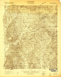 1921 Meridian1921 Print · USGSMeridian and Lauderdale County thrive as a major railroad hub in the early twenties. Researchers can trace family sites and community landmarks like Magnolia White Place, Knox Mill, and Cokers Chapel.4 unique versions available
 - 1923 Map of Meridian
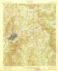 1923 Meridian1923 Print · USGSMeridian emerged as a critical Mississippi rail junction in the early 1920s, anchoring a network of lines that fueled the local economy. Researchers can trace dozens of country landmarks, from Old Marion Cemetery to rural hubs like Garretts Store and Vimville.2 unique versions available
End of results
Showing maps 1-2 of 2
Top cities near Bailey
Frequently asked questions
- What are the different types of historical maps available for Bailey?
- What is the oldest map of Bailey?
- Where can I purchase historical maps of Bailey for my home or office?
- Where can I download high-res historical maps of Bailey?
- Are there historical topographic maps available for Bailey?
- Is there historical aerial imagery available for Bailey?
- Where are historical maps of Bailey sourced from?