1940s Maps of Saint Patrick, Missouri
Explore 1 historic maps of Saint Patrick from the 1940s. These maps offer a rare glimpse into what life looked like during the 1940s — showing old roads, neighborhoods, homes, and landmarks that have changed or disappeared over time.
Whether you're researching your family's past, planning a metal detecting trip, or studying how Saint Patrick's landscape evolved across the 1940s, these high-resolution maps are a powerful tool for exploring the history of this region.
- Focus on a specific era: All maps on this page are from the 1940s, giving you a focused view of this time period.
- See what’s changed: Compare century-old streets, trails, and buildings to today's modern landscape using overlays and satellite layers.
- Research with precision: Use these maps for genealogy, historical research, land use analysis, or educational projects.
- View, download, or print: Maps are fully viewable online in high resolution, and can be downloaded or printed for your own records.
Start exploring Saint Patrick's history through authentic maps from the 1940s. This is your window into the past.
Saint Patrick, MO maps
(1)- 1949 Map of St. Patrick, 1977 Print
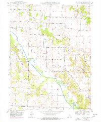 1949 St. Patrick1977 Print · USGSNortheast Missouri’s rural landscape is captured here at mid-century, just as the network of one-room country schools began to fade. Genealogists can locate family landmarks like the Pride of the West Sch, Honey Creek Cem, and the village of St Patrick.
End of results
Showing maps 1-1 of 1
Top cities near Saint Patrick
- Keokuk historical maps
- Hamilton historical maps
- Canton historical maps
- Kahoka historical maps
- Warsaw historical maps
- La Grange historical maps
See more
Frequently asked questions
- What are the different types of historical maps available for Saint Patrick?
- What is the oldest map of Saint Patrick?
- Where can I purchase historical maps of Saint Patrick for my home or office?
- Where can I download high-res historical maps of Saint Patrick?
- Are there historical topographic maps available for Saint Patrick?
- Is there historical aerial imagery available for Saint Patrick?
- Where are historical maps of Saint Patrick sourced from?