1940s Maps of Gladden, Missouri
Explore 4 historic maps of Gladden from the 1940s. These maps offer a rare glimpse into what life looked like during the 1940s — showing old roads, neighborhoods, homes, and landmarks that have changed or disappeared over time.
Whether you're researching your family's past, planning a metal detecting trip, or studying how Gladden's landscape evolved across the 1940s, these high-resolution maps are a powerful tool for exploring the history of this region.
- Focus on a specific era: All maps on this page are from the 1940s, giving you a focused view of this time period.
- See what’s changed: Compare century-old streets, trails, and buildings to today's modern landscape using overlays and satellite layers.
- Research with precision: Use these maps for genealogy, historical research, land use analysis, or educational projects.
- View, download, or print: Maps are fully viewable online in high resolution, and can be downloaded or printed for your own records.
Start exploring Gladden's history through authentic maps from the 1940s. This is your window into the past.
Gladden, MO maps
(4)- 1945 Map of Round Spring, 1962 Print
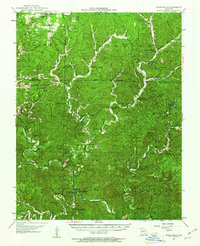 1945 Round Spring1962 Print · USGSThe Ozark hill country of Shannon County comes to life in the mid-1940s, revealing a landscape of remote hollows and riverside camps. Genealogists and historians can trace old community hubs like the Brushy Post Office, Mauser's Mill, and several country schools.2 unique versions available
 - 1947 Map of Sinkin
 1947 Sinkin1947 Print · USGSShannon County in the late 1940s reveals a landscape of spring-fed rivers and remote timber settlements. Genealogists and historians can locate numerous rural schools like Sugar Tree Grove Sch and trace the river-mill economy at Brushy Mill and Mansers Mill.
 - 1949 Map of Round Spring
 1949 Round Spring1949 Print · USGSThe Ozark riverways of Shannon and Dent Counties are captured here in the late 1940s as state and federal forestry lands began to consolidate. Local researchers can trace family roots through remote landmarks like Swinney Cem, Falk Mill, and the isolated Brushy PO.
 - 1949 Map of Rolla, 1950 Print
 1949 Rolla1950 Print · USGSThe Missouri Ozarks are captured here just after the war, showing a landscape of deep river valleys and emerging reservoir projects. Genealogists and historians can trace the mining towns of Bonne Terre and Potosi or follow the early route of U.S. Highway 66.
End of results
Showing maps 1-4 of 4
Top cities near Gladden
Frequently asked questions
- What are the different types of historical maps available for Gladden?
- What is the oldest map of Gladden?
- Where can I purchase historical maps of Gladden for my home or office?
- Where can I download high-res historical maps of Gladden?
- Are there historical topographic maps available for Gladden?
- Is there historical aerial imagery available for Gladden?
- Where are historical maps of Gladden sourced from?