1980s Maps of Bland, Missouri
Explore 3 historic maps of Bland from the 1980s. These maps offer a rare glimpse into what life looked like during the 1980s — showing old roads, neighborhoods, homes, and landmarks that have changed or disappeared over time.
Whether you're researching your family's past, planning a metal detecting trip, or studying how Bland's landscape evolved across the 1980s, these high-resolution maps are a powerful tool for exploring the history of this region.
- Focus on a specific era: All maps on this page are from the 1980s, giving you a focused view of this time period.
- See what’s changed: Compare century-old streets, trails, and buildings to today's modern landscape using overlays and satellite layers.
- Research with precision: Use these maps for genealogy, historical research, land use analysis, or educational projects.
- View, download, or print: Maps are fully viewable online in high resolution, and can be downloaded or printed for your own records.
Start exploring Bland's history through authentic maps from the 1980s. This is your window into the past.
Bland, MO maps
(3)- 1981 Map of Belle
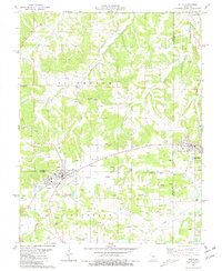 1981 Belle1981 Print · USGSThe tri-county borderlands of Maries, Gasconade, and Osage Counties come alive in this early 1980s survey of the Missouri uplands. Local historians can trace the network of clay mining and rural life through landmarks like Beulah Ch and numerous family plots such as Backues Cem and Heyer Cem.
 - 1981 Map of Owensville West
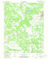 1981 Owensville West1981 Print · USGSGasconade County was a center of clay mining and rural commerce in the early eighties. Genealogists and historians can trace numerous family burial sites like Old Bland Cem and Howard Cem, alongside the industrial legacy of many scattered Claypits.
 - 1985 Map of Sullivan
 1985 Sullivan1985 Print · USGSMid-1980s Missouri comes into focus here as the Ozark landscape balances industrial mining with river recreation. Genealogists and historians can trace the St Louis-San Francisco RR through Sullivan and locate landmarks like Pea Ridge Mine or St Cloud Church.3 unique versions available
End of results
Showing maps 1-3 of 3
Top cities near Bland
Frequently asked questions
- What are the different types of historical maps available for Bland?
- What is the oldest map of Bland?
- Where can I purchase historical maps of Bland for my home or office?
- Where can I download high-res historical maps of Bland?
- Are there historical topographic maps available for Bland?
- Is there historical aerial imagery available for Bland?
- Where are historical maps of Bland sourced from?