1940s Maps of Brookfield, Missouri
Explore 2 historic maps of Brookfield from the 1940s. These maps offer a rare glimpse into what life looked like during the 1940s — showing old roads, neighborhoods, homes, and landmarks that have changed or disappeared over time.
Whether you're researching your family's past, planning a metal detecting trip, or studying how Brookfield's landscape evolved across the 1940s, these high-resolution maps are a powerful tool for exploring the history of this region.
- Focus on a specific era: All maps on this page are from the 1940s, giving you a focused view of this time period.
- See what’s changed: Compare century-old streets, trails, and buildings to today's modern landscape using overlays and satellite layers.
- Research with precision: Use these maps for genealogy, historical research, land use analysis, or educational projects.
- View, download, or print: Maps are fully viewable online in high resolution, and can be downloaded or printed for your own records.
Start exploring Brookfield's history through authentic maps from the 1940s. This is your window into the past.
Brookfield, MO maps
(2)- 1946 Map of Brookfield, 1979 Print
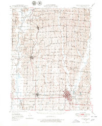 1946 Brookfield1979 Print · USGSLinn County is captured here in the mid-1940s, showing a landscape defined by the Chicago Burlington and Quincy rail line and dozens of rural school districts. Genealogists can trace family roots through numerous sites like South Salem Cem, Magnolia Ch, and the Prairie Seminary Sch.
 - 1948 Map of Brookfield
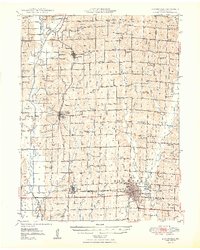 1948 Brookfield1948 Print · USGSLinn County in the late 1940s is defined by its busy rail corridors and a remarkably dense network of small rural school districts. Genealogists and historians can trace the foundations of local life at Prairie Seminary Sch, Dryden Cem, and Laclede.2 unique versions available
End of results
Showing maps 1-2 of 2
Top cities near Brookfield
- Marceline historical maps
- Bucklin historical maps
- Meadville historical maps
- Laclede historical maps
- Linneus historical maps
- Cunningham historical maps
See more
Frequently asked questions
- What are the different types of historical maps available for Brookfield?
- What is the oldest map of Brookfield?
- Where can I purchase historical maps of Brookfield for my home or office?
- Where can I download high-res historical maps of Brookfield?
- Are there historical topographic maps available for Brookfield?
- Is there historical aerial imagery available for Brookfield?
- Where are historical maps of Brookfield sourced from?