1980s Maps of Pineville, Missouri
Explore 3 historic maps of Pineville from the 1980s. These maps offer a rare glimpse into what life looked like during the 1980s — showing old roads, neighborhoods, homes, and landmarks that have changed or disappeared over time.
Whether you're researching your family's past, planning a metal detecting trip, or studying how Pineville's landscape evolved across the 1980s, these high-resolution maps are a powerful tool for exploring the history of this region.
- Focus on a specific era: All maps on this page are from the 1980s, giving you a focused view of this time period.
- See what’s changed: Compare century-old streets, trails, and buildings to today's modern landscape using overlays and satellite layers.
- Research with precision: Use these maps for genealogy, historical research, land use analysis, or educational projects.
- View, download, or print: Maps are fully viewable online in high resolution, and can be downloaded or printed for your own records.
Start exploring Pineville's history through authentic maps from the 1980s. This is your window into the past.
Pineville, MO maps
(3)- 1982 Map of Noel
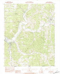 1982 Noel1982 Print · USGSThe Elk River valley and the southern reaches of McDonald County are shown in the early eighties as a network of river towns and hollows. Trace the paths between Noel, Pineville, and Elk Springs or locate rural landmarks like Deer Lick Spring and Bosky-Dell.
 - 1982 Map of Jane
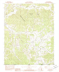 1982 Jane1982 Print · USGSThe Ozark highlands of southern Missouri come into focus during the early eighties, showing the rural character of Jane and the surrounding hollows. Researchers can trace land details from Big Sugar Creek to family-named landmarks like Whittaker Spring and Bobs Knob.
 - 1986 Map of Neosho
 1986 Neosho1986 Print · USGSThe tri-state border region comes alive in the mid-eighties as a landscape of mining heritage and river valleys. Researchers can trace the rail lines of the Kansas City Southern Ry and locate rural landmarks like Gibson Cem and Peoria.2 unique versions available
End of results
Showing maps 1-3 of 3
Top cities near Pineville
- Rogers historical maps
- Bentonville historical maps
- Bella Vista historical maps
- Centerton historical maps
- Neosho historical maps
- Gravette historical maps
See more
Top neighborhoods of Pineville
Frequently asked questions
- What are the different types of historical maps available for Pineville?
- What is the oldest map of Pineville?
- Where can I purchase historical maps of Pineville for my home or office?
- Where can I download high-res historical maps of Pineville?
- Are there historical topographic maps available for Pineville?
- Is there historical aerial imagery available for Pineville?
- Where are historical maps of Pineville sourced from?