1950s Maps of Tower Grove South, St. Louis
Explore 2 historic maps of Tower Grove South from the 1950s. These maps offer a rare glimpse into what life looked like during the 1950s — showing old roads, neighborhoods, homes, and landmarks that have changed or disappeared over time.
Whether you're researching your family's past, planning a metal detecting trip, or studying how Tower Grove South's landscape evolved across the 1950s, these high-resolution maps are a powerful tool for exploring the history of this region.
- Focus on a specific era: All maps on this page are from the 1950s, giving you a focused view of this time period.
- See what’s changed: Compare century-old streets, trails, and buildings to today's modern landscape using overlays and satellite layers.
- Research with precision: Use these maps for genealogy, historical research, land use analysis, or educational projects.
- View, download, or print: Maps are fully viewable online in high resolution, and can be downloaded or printed for your own records.
Start exploring Tower Grove South's history through authentic maps from the 1950s. This is your window into the past.
Tower Grove South, St. Louis maps
(2)- 1954 Map of Webster Groves, 1959 Print
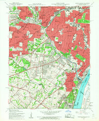 1954 Webster Groves1959 Print · USGSMid-century St. Louis and Webster Groves appear here during a period of rapid suburban maturation and institutional development. Genealogists can trace family sites near Jefferson Barracks, Resurrection Cemetery, and Luxemburg.5 unique versions available
 - 1954 Map of Cahokia, 1959 Print
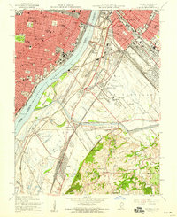 1954 Cahokia1959 Print · USGSMid-century St. Louis and East St. Louis are documented here at a peak of rail and river industry along the Mississippi River. Genealogists and historians can trace local landmarks from Old Cathedral and Holy Family Cem to the early aviation history of Parks Metropolitan Airport.5 unique versions available
End of results
Showing maps 1-2 of 2
Frequently asked questions
- What are the different types of historical maps available for Tower Grove South?
- What is the oldest map of Tower Grove South?
- Where can I purchase historical maps of Tower Grove South for my home or office?
- Where can I download high-res historical maps of Tower Grove South?
- Are there historical topographic maps available for Tower Grove South?
- Is there historical aerial imagery available for Tower Grove South?
- Where are historical maps of Tower Grove South sourced from?