1960s Maps of Birds Corner, Missouri
Explore 2 historic maps of Birds Corner from the 1960s. These maps offer a rare glimpse into what life looked like during the 1960s — showing old roads, neighborhoods, homes, and landmarks that have changed or disappeared over time.
Whether you're researching your family's past, planning a metal detecting trip, or studying how Birds Corner's landscape evolved across the 1960s, these high-resolution maps are a powerful tool for exploring the history of this region.
- Focus on a specific era: All maps on this page are from the 1960s, giving you a focused view of this time period.
- See what’s changed: Compare century-old streets, trails, and buildings to today's modern landscape using overlays and satellite layers.
- Research with precision: Use these maps for genealogy, historical research, land use analysis, or educational projects.
- View, download, or print: Maps are fully viewable online in high resolution, and can be downloaded or printed for your own records.
Start exploring Birds Corner's history through authentic maps from the 1960s. This is your window into the past.
Birds Corner, MO maps
(2)- 1963 Map of Clines Island, 1964 Print
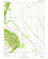 1963 Clines Island1964 Print · USGSSoutheast Missouri farming life is captured here in the early sixties, as the St Louis Southwestern Railroad served a network of rural hamlets. Genealogists can locate family landmarks like Palmer Cem, Garden Ridge Ch, and the site of Beech Grove Sch.
 - 1963 Map of Bloomfield, 1967 Print
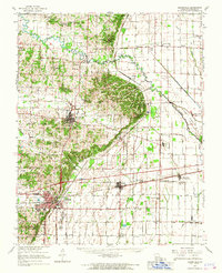 1963 Bloomfield1967 Print · USGSStoddard County in the early sixties showcases the managed landscapes of the Missouri Bootheel as the area transitioned into an agricultural powerhouse. Genealogists and historians can trace family locations near Dexter, identify rural landmarks like St Joe Ch, or locate the St Louis Southwestern Railroad tracks.
End of results
Showing maps 1-2 of 2
Top cities near Birds Corner
- Sikeston historical maps
- Dexter historical maps
- Bloomfield historical maps
- Bernie historical maps
- Oran historical maps
- Advance historical maps
See more
Frequently asked questions
- What are the different types of historical maps available for Birds Corner?
- What is the oldest map of Birds Corner?
- Where can I purchase historical maps of Birds Corner for my home or office?
- Where can I download high-res historical maps of Birds Corner?
- Are there historical topographic maps available for Birds Corner?
- Is there historical aerial imagery available for Birds Corner?
- Where are historical maps of Birds Corner sourced from?