1970s Maps of Cape Fair, Missouri
Explore 1 historic maps of Cape Fair from the 1970s. These maps offer a rare glimpse into what life looked like during the 1970s — showing old roads, neighborhoods, homes, and landmarks that have changed or disappeared over time.
Whether you're researching your family's past, planning a metal detecting trip, or studying how Cape Fair's landscape evolved across the 1970s, these high-resolution maps are a powerful tool for exploring the history of this region.
- Focus on a specific era: All maps on this page are from the 1970s, giving you a focused view of this time period.
- See what’s changed: Compare century-old streets, trails, and buildings to today's modern landscape using overlays and satellite layers.
- Research with precision: Use these maps for genealogy, historical research, land use analysis, or educational projects.
- View, download, or print: Maps are fully viewable online in high resolution, and can be downloaded or printed for your own records.
Start exploring Cape Fair's history through authentic maps from the 1970s. This is your window into the past.
Cape Fair, MO maps
(1)- 1974 Map of Cape Fair, 1977 Print
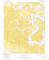 1974 Cape Fair1977 Print · USGSThe James River and Table Rock Lake define this Stone County landscape in the 1970s, showcasing a mix of deep Ozark hollows and modern lakefront access. Genealogists and hikers can locate Cape Fair Cem, the Woolly Creek Community Hall, and the remote Piney Creek Cave.
End of results
Showing maps 1-1 of 1
Top cities near Cape Fair
- Branson historical maps
- Aurora historical maps
- Kimberling City historical maps
- Crane historical maps
- Highlandville historical maps
- Reeds Spring historical maps
See more
Frequently asked questions
- What are the different types of historical maps available for Cape Fair?
- What is the oldest map of Cape Fair?
- Where can I purchase historical maps of Cape Fair for my home or office?
- Where can I download high-res historical maps of Cape Fair?
- Are there historical topographic maps available for Cape Fair?
- Is there historical aerial imagery available for Cape Fair?
- Where are historical maps of Cape Fair sourced from?