1900s (20th Century) Maps of Plato, Missouri
Explore 12 historic maps of Plato from the 1900s (20th Century). These maps offer a rare glimpse into what life looked like during the 1900s — showing old roads, neighborhoods, homes, and landmarks that have changed or disappeared over time.
Whether you're researching your family's past, planning a metal detecting trip, or studying how Plato's landscape evolved across the 1900s, these high-resolution maps are a powerful tool for exploring the history of this region.
- Focus on a specific era: All maps on this page are from the 1900s, giving you a focused view of this time period.
- See what’s changed: Compare century-old streets, trails, and buildings to today's modern landscape using overlays and satellite layers.
- Research with precision: Use these maps for genealogy, historical research, land use analysis, or educational projects.
- View, download, or print: Maps are fully viewable online in high resolution, and can be downloaded or printed for your own records.
Start exploring Plato's history through authentic maps from the 1900s. This is your window into the past.
Plato, MO maps
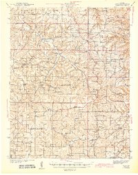
(12)- 1941 Map of Big Piney
 1941 Big Piney1941 Print · USGSThe Ozarks at the dawn of the war years reveal a landscape of rural schoolhouses and river bends before military expansion. Genealogists can trace family roots through Lone Star Sch, Cook Cem, and the now-transformed settlement of Bloodland.
 - 1941 Map of Bado, 1974 Print
 1941 Bado1974 Print · USGSTexas County, Missouri, is documented here in the early 1940s, showing a landscape of small upland farms and forest communities. Genealogists can trace family roots through numerous sites like Old Union Cem, Bucyrus, and Pleasant Ridge Sch.
 - 1943 Map of Big Piney
 1943 Big Piney1943 Print · USGSThe Missouri Ozarks are shown here during the early years of the Second World War as federal land expansion reshaped the region. Genealogists and local historians can trace family roots through numerous country schools like Lone Star Sch and churches including St Annie Ch and Dondas Ch.2 unique versions available
 - 1943 Map of Bado
 1943 Bado1943 Print · USGSThe Missouri Ozarks are captured here in the early 1940s, showing a landscape defined by the Mark Twain National Forest and rural river valleys. Genealogists can trace family roots through numerous landmarks like Lynch Cem, Ragsdale Sch, and the Barium Mine.3 unique versions available
 - 1954 Map of Springfield
 1954 Springfield1954 Print · USGSThe Missouri Ozarks are captured here during the post-war era, showing the expansion of Springfield and the surrounding river valleys. Genealogists and historians can trace local landmarks like Mount Comfort Cemetery and the Fort Leonard Wood military grounds.6 unique versions available
 - 1954 Map of Big Piney, 1958 Print
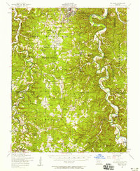 1954 Big Piney1958 Print · USGSThe mid-century Ozark highlands are captured here during a period of massive federal transition, as military expansion met traditional rural life. Researchers can trace family names and vanished sites through the Bloodland Cemetery, the Roby Lookout Tower, and several abandoned schoolhouses like Morman Valley School.3 unique versions available
 - 1954 Map of Roby, 1959 Print
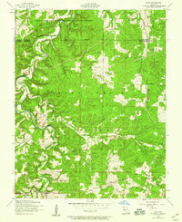 1954 Roby1959 Print · USGSThe Missouri Ozarks during the mid-1950s reveals a landscape of dense national forest and expanding military grounds. Genealogists can trace family footprints at Macedonia Cemetery or locate the former sites of rural education at Bloodland School and Blackjack School.3 unique versions available
 - 1958 Map of Springfield
 1958 Springfield1958 Print · USGSThe Missouri Ozarks are captured during the mid-century era of growth, centered on the bustling hub of Springfield. Genealogists and historians can trace family roots through numerous landmarks like Ebenezer Church, Stockton Cem, and the various county courthouses.
 - 1959 Map of Springfield
 1959 Springfield1959 Print · USGSThe Missouri Ozarks are captured here during a decade of postwar growth and increasing highway connectivity. Researchers can trace the legacy of the St Louis-San Francisco RR and locate early sites in Springfield, Lebanon, and Mountain Grove.
 - 1982 Map of Lebanon, 1983 Print
 1982 Lebanon1983 Print · USGSThe Missouri Ozarks are captured in the early eighties as Interstate 44 and the St Louis-San Francisco rail line link growing towns with the Fort Leonard Wood Military Reservation. Genealogists and historians can trace family-named sites like Flatwood Church and old post offices at Sleeper and Nebo.
 - 1983 Map of Mountain Grove
 1983 Mountain Grove1983 Print · USGSWright and Webster counties in the early 1980s show a traditional Ozark landscape of ridge-running railroads and river headwaters. You can trace the Burlington Northern Railroad through towns like Mansfield or find rural landmarks like Vance Cem and Mt Zion Church.
 - 1987 Map of Roubidoux
 1987 Roubidoux1987 Print · USGSTexas County, Missouri, in the late eighties remains a landscape of deep timber and winding river valleys. Researchers can trace the rural road networks connecting Turley and Roubidoux or locate family ties along Roubidoux Creek and Mill Creek.
End of results
Showing maps 1-12 of 12
Top cities near Plato
Frequently asked questions
- What are the different types of historical maps available for Plato?
- What is the oldest map of Plato?
- Where can I purchase historical maps of Plato for my home or office?
- Where can I download high-res historical maps of Plato?
- Are there historical topographic maps available for Plato?
- Is there historical aerial imagery available for Plato?
- Where are historical maps of Plato sourced from?