Old Maps of Warren County, Missouri
Explore 38 old maps of Warren County, spanning from 1890 to today. These high-resolution historic maps reveal how streets, neighborhoods, landmarks, and natural features evolved over time — perfect for genealogy, metal detecting, research, and local history exploration.
What you can do with these maps:
- See how Warren County changed over time: Compare historical maps to modern-day views to trace roads, homesites, rail lines & more.
- View detailed metadata: Each map includes creators, publishers, year, scale, and archive source.
- Overlay maps with satellite & LiDAR: Visualize the past alongside modern tools to explore terrain & human change.
- Trusted historical sources: Maps sourced from the USGS, Library of Congress, and other archives.
- Access maps your way: View online, download high-res files, or order prints for personal or research use.
Start exploring old maps of Warren County to uncover forgotten places, hidden landmarks, and the deep history beneath your feet.
Warren County, MO maps
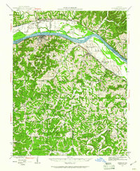
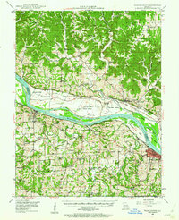
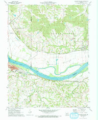
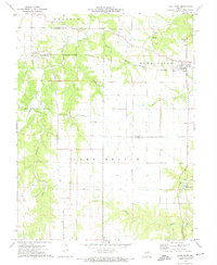
(38)- 1890 Map of Hermann
 1890 Hermann1890 Print · USGSCovers Warren County, including Washington, Troy, and other nearby areas5 unique versions available
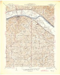
 - 1903 Map of O'Fallon
 1903 O'Fallon1903 Print · USGSCovers Warren County, including O'Fallon, Saint Charles, and other nearby areas5 unique versions available
 - 1936 Map of Hermann
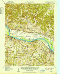
 1936 Hermann1936 Print · USGSCovers Warren County, including Hermann, Berger, and other nearby areas
 - 1941 Map of Troy, 1964 Print
 1941 Troy1964 Print · USGSCovers Warren County, including O'Fallon, Wentzville, and other nearby areas2 unique versions available
 - 1942 Map of Hermann, 1961 Print
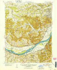
 1942 Hermann1961 Print · USGSCovers Warren County, including Hermann, Berger, and other nearby areas2 unique versions available
 - 1942 Map of New Florence, 1963 Print
 1942 New Florence1963 Print · USGSCovers Warren County, including Montgomery City, New Florence, and other nearby areas2 unique versions available
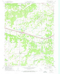
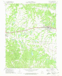
 - 1943 Map of Warrenton, 1962 Print
 1943 Warrenton1962 Print · USGSCovers Warren County, including Troy, Warrenton, and other nearby areas2 unique versions available
 - 1945 Map of Troy
 1945 Troy1945 Print · USGSCovers Warren County, including O'Fallon, Wentzville, and other nearby areas2 unique versions available
 - 1945 Map of Hermann
 1945 Hermann1945 Print · USGSCovers Warren County, including Hermann, Berger, and other nearby areas2 unique versions available
 - 1945 Map of Warrenton
 1945 Warrenton1945 Print · USGSCovers Warren County, including Troy, Warrenton, and other nearby areas2 unique versions available
 - 1946 Map of New Florence
 1946 New Florence1946 Print · USGSCovers Warren County, including Montgomery City, New Florence, and other nearby areas2 unique versions available
 - 1948 Map of Washington, 1962 Print
 1948 Washington1962 Print · USGSCovers Warren County, including Washington, New Haven, and other nearby areas2 unique versions available
 - 1948 Map of Augusta, 1963 Print
 1948 Augusta1963 Print · USGSCovers Warren County, including O'Fallon, Washington, and other nearby areas2 unique versions available
 - 1949 Map of Saint Louis
 1949 Saint Louis1949 Print · USGSCovers Warren County, including St. Louis, O'Fallon, and other nearby areas2 unique versions available
 - 1949 Map of Washington
 1949 Washington1949 Print · USGSCovers Warren County, including Washington, New Haven, and other nearby areas2 unique versions available
 - 1949 Map of Augusta
 1949 Augusta1949 Print · USGSCovers Warren County, including O'Fallon, Washington, and other nearby areas2 unique versions available
 - 1962 Map of St. Louis
 1962 St. Louis1962 Print · USGSCovers Warren County, including St. Louis, O'Fallon, and other nearby areas
 - 1963 Map of St. Louis, 1970 Print
 1963 St. Louis1970 Print · USGSCovers Warren County, including St. Louis, O'Fallon, and other nearby areas4 unique versions available
 - 1966 Map of St. Louis
 1966 St. Louis1966 Print · USGSCovers Warren County, including St. Louis, O'Fallon, and other nearby areas
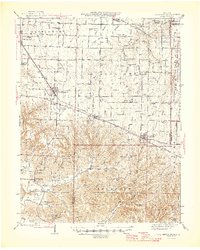
 - 1972 Map of Foristell, 1973 Print
 1972 Foristell1973 Print · USGSCovers Warren County, including Wentzville, Wright City, and other nearby areas3 unique versions available
 - 1972 Map of Washington East, 1973 Print
 1972 Washington East1973 Print · USGSCovers Warren County, including Washington, Augusta, and other nearby areas
 - 1972 Map of New Melle, 1973 Print
 1972 New Melle1973 Print · USGSCovers Warren County, including New Melle, Cappeln, and other nearby areas2 unique versions available
 - 1972 Map of Wright City, 1974 Print
 1972 Wright City1974 Print · USGSCovers Warren County, including Warrenton, Wright City, and other nearby areas2 unique versions available
 - 1972 Map of Marthasville, 1975 Print
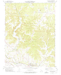 1972 Marthasville1975 Print · USGSCovers Warren County, including Marthasville, Innsbrook, and other nearby areas2 unique versions available
 - 1973 Map of Hawk Point, 1974 Print
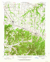
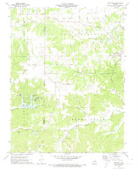
 1973 Hawk Point1974 Print · USGSCovers Warren County, including Hawk Point, Truxton, and other nearby areas2 unique versions available
Showing maps 1-25 of 38
Top cities of Warren County
- Warrenton historical maps
- Wright City historical maps
- Marthasville historical maps
- Truesdale historical maps
- Innsbrook historical maps
- Pendleton historical maps
See more
Frequently asked questions
- What are the different types of historical maps available for Warren County?
- What is the oldest map of Warren County?
- Where can I purchase historical maps of Warren County for my home or office?
- Where can I download high-res historical maps of Warren County?
- Are there historical topographic maps available for Warren County?
- Is there historical aerial imagery available for Warren County?
- Where are historical maps of Warren County sourced from?