1900s (20th Century) Maps of Lewistown Junction, Montana
Explore 6 historic maps of Lewistown Junction from the 1900s (20th Century). These maps offer a rare glimpse into what life looked like during the 1900s — showing old roads, neighborhoods, homes, and landmarks that have changed or disappeared over time.
Whether you're researching your family's past, planning a metal detecting trip, or studying how Lewistown Junction's landscape evolved across the 1900s, these high-resolution maps are a powerful tool for exploring the history of this region.
- Focus on a specific era: All maps on this page are from the 1900s, giving you a focused view of this time period.
- See what’s changed: Compare century-old streets, trails, and buildings to today's modern landscape using overlays and satellite layers.
- Research with precision: Use these maps for genealogy, historical research, land use analysis, or educational projects.
- View, download, or print: Maps are fully viewable online in high resolution, and can be downloaded or printed for your own records.
Start exploring Lewistown Junction's history through authentic maps from the 1900s. This is your window into the past.
Lewistown Junction, MT maps
(6)- 1941 Map of Lewistown, 1959 Print
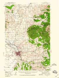 1941 Lewistown1959 Print · USGSFergus County's mining and ranching heart comes into focus during the early 1940s as the Judith Mountains overlook a bustling rail-fed valley. Trace the legacy of local industry through the Divide Coal Mine, the Heath Post Office, and the early footprint of the Lewistown Airport.3 unique versions available
 - 1944 Map of Lewistown
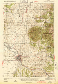 1944 Lewistown1944 Print · USGSFergus County at the height of the mid-century mining and rail era reveals a landscape shaped by resource extraction and high-plains settlement. Researchers can trace the legacy of local industry through the Divide Coal Mine, the Oil Refinery, and the State Fish Hatchery.2 unique versions available
 - 1954 Map of Lewistown, 1967 Print
 1954 Lewistown1967 Print · USGSCentral Montana at the height of the mid-century rail era reveals a landscape shaped by the Judith River and high mountain ranges. Trace the old lines of the Great Northern through Lewistown and Denton, or locate sites like Giltedge and Landusky.3 unique versions available
 - 1959 Map of Lewistown
 1959 Lewistown1959 Print · USGSCentral Montana in the mid-1950s shows a landscape defined by the winding Missouri River and the rise of the South Moccasin Mtns. Researchers can trace the rail lines of the Great Northern through towns like Winifred and locate the Cat Creek Oil Field.3 unique versions available
 - 1978 Map of Lewistown, 1994 Print
 1978 Lewistown1994 Print · USGSThe heart of central Montana comes alive in the late seventies, centered on the hub of Lewistown and the high summits of the Judith Mountains. Researchers can trace the Burlington Northern rail lines and locate specific regional landmarks like Giltedge, Spring Creek Colony, and Moccasin.
 - 1985 Map of Lewistown, 1986 Print
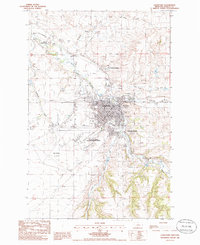 1985 Lewistown1986 Print · USGSMid-century Fergus County comes into focus in this detailed study of the area's rail junctions and resource hubs. Genealogists and historians can trace the footprint of Lewistown near the Fish Hatchery, Cem, and Roy-Winifred Junction.
End of results
Showing maps 1-6 of 6
Top cities near Lewistown Junction
Frequently asked questions
- What are the different types of historical maps available for Lewistown Junction?
- What is the oldest map of Lewistown Junction?
- Where can I purchase historical maps of Lewistown Junction for my home or office?
- Where can I download high-res historical maps of Lewistown Junction?
- Are there historical topographic maps available for Lewistown Junction?
- Is there historical aerial imagery available for Lewistown Junction?
- Where are historical maps of Lewistown Junction sourced from?