1990s Maps of Saint Regis, Montana
Explore 2 historic maps of Saint Regis from the 1990s. These maps offer a rare glimpse into what life looked like during the 1990s — showing old roads, neighborhoods, homes, and landmarks that have changed or disappeared over time.
Whether you're researching your family's past, planning a metal detecting trip, or studying how Saint Regis's landscape evolved across the 1990s, these high-resolution maps are a powerful tool for exploring the history of this region.
- Focus on a specific era: All maps on this page are from the 1990s, giving you a focused view of this time period.
- See what’s changed: Compare century-old streets, trails, and buildings to today's modern landscape using overlays and satellite layers.
- Research with precision: Use these maps for genealogy, historical research, land use analysis, or educational projects.
- View, download, or print: Maps are fully viewable online in high resolution, and can be downloaded or printed for your own records.
Start exploring Saint Regis's history through authentic maps from the 1990s. This is your window into the past.
Saint Regis, MT maps
(2)- 1994 Map of Wallace
 1994 Wallace1994 Print · USGSThe Bitterroot Mountains and the mining heart of the Silver Valley are captured here in the mid-1990s. Researchers can locate active and historic mineral operations such as the Argentine Mine and Last Chance Mines, while tracing the Milwaukee Road through the high passes.
 - 1999 Map of Saint Regis, 2003 Print
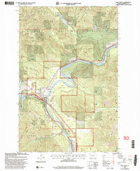 1999 Saint Regis2003 Print · USGSThe mountain town of St Regis appears at the turn of the millennium as a vital forestry and travel hub along the Clark Fork. Researchers can trace the local infrastructure of the era, from the St Regis Work Center and Heliport to the town Cem.
End of results
Showing maps 1-2 of 2
Top cities near Saint Regis
Frequently asked questions
- What are the different types of historical maps available for Saint Regis?
- What is the oldest map of Saint Regis?
- Where can I purchase historical maps of Saint Regis for my home or office?
- Where can I download high-res historical maps of Saint Regis?
- Are there historical topographic maps available for Saint Regis?
- Is there historical aerial imagery available for Saint Regis?
- Where are historical maps of Saint Regis sourced from?