1900s (20th Century) Maps of Conner, Montana
Explore 4 historic maps of Conner from the 1900s (20th Century). These maps offer a rare glimpse into what life looked like during the 1900s — showing old roads, neighborhoods, homes, and landmarks that have changed or disappeared over time.
Whether you're researching your family's past, planning a metal detecting trip, or studying how Conner's landscape evolved across the 1900s, these high-resolution maps are a powerful tool for exploring the history of this region.
- Focus on a specific era: All maps on this page are from the 1900s, giving you a focused view of this time period.
- See what’s changed: Compare century-old streets, trails, and buildings to today's modern landscape using overlays and satellite layers.
- Research with precision: Use these maps for genealogy, historical research, land use analysis, or educational projects.
- View, download, or print: Maps are fully viewable online in high resolution, and can be downloaded or printed for your own records.
Start exploring Conner's history through authentic maps from the 1900s. This is your window into the past.
Conner, MT maps
(4)- 1956 Map of Elk City, 1963 Print
 1956 Elk City1963 Print · USGSThe Idaho backcountry in the mid-fifties remains a landscape of isolated mining camps and remote forest outposts. Researchers can trace historical mining operations at Stibnite Mine and Blackbird Mine or locate riverside landmarks like Mackay Bar and Campbell's Ferry.3 unique versions available
 - 1960 Map of Elk City
 1960 Elk City1960 Print · USGSThe Central Idaho wilderness and Bitterroot Range are captured here during the peak of mid-century industrial mining. Researchers can trace remote backcountry settlements like Burgdorf and Warren, alongside major mineral sites including the Blackbird Mine and Ima Mine.2 unique versions available
 - 1964 Map of Robbins Gulch, 1968 Print
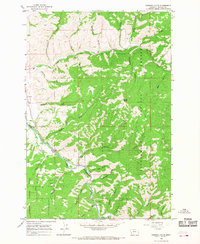 1964 Robbins Gulch1968 Print · USGSThe Bitterroot Valley in the mid-sixties reveals a landscape of isolated mountain settlements and national forest land. Genealogists and researchers can locate Conner, the Conner Ch, and the riverside Landing Strip along the East Fork Bitterroot River.2 unique versions available
 - 1998 Map of Robbins Gulch, 2002 Print
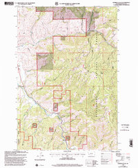 1998 Robbins Gulch2002 Print · USGSRavalli County mountain life is centered on the East Fork Bitterroot River in this late-twentieth-century study. Genealogists and historians can trace the settlement at Conner, find the Corner Ch, or locate family-named landmarks like Beam Flat and Doran Point.
End of results
Showing maps 1-4 of 4
Top cities near Conner
Frequently asked questions
- What are the different types of historical maps available for Conner?
- What is the oldest map of Conner?
- Where can I purchase historical maps of Conner for my home or office?
- Where can I download high-res historical maps of Conner?
- Are there historical topographic maps available for Conner?
- Is there historical aerial imagery available for Conner?
- Where are historical maps of Conner sourced from?