1900s (20th Century) Maps of Nashua, Montana
Explore 7 historic maps of Nashua from the 1900s (20th Century). These maps offer a rare glimpse into what life looked like during the 1900s — showing old roads, neighborhoods, homes, and landmarks that have changed or disappeared over time.
Whether you're researching your family's past, planning a metal detecting trip, or studying how Nashua's landscape evolved across the 1900s, these high-resolution maps are a powerful tool for exploring the history of this region.
- Focus on a specific era: All maps on this page are from the 1900s, giving you a focused view of this time period.
- See what’s changed: Compare century-old streets, trails, and buildings to today's modern landscape using overlays and satellite layers.
- Research with precision: Use these maps for genealogy, historical research, land use analysis, or educational projects.
- View, download, or print: Maps are fully viewable online in high resolution, and can be downloaded or printed for your own records.
Start exploring Nashua's history through authentic maps from the 1900s. This is your window into the past.
Nashua, MT maps
(7)- 1914 Map of Nashua, 1965 Print
 1914 Nashua1965 Print · USGSNortheastern Montana ranching and rail life are captured here in the early twentieth century. Researchers can trace rural school locations like Panton School and Galpin School or locate early family holdings such as Nichols Ranch.
 - 1916 Map of Nashua
 1916 Nashua1916 Print · USGSNortheastern Montana at the height of the homesteading era reveals the vital connection between the rail lines and river valleys. Genealogists and historians can locate early rural schoolhouses like Penton School and Galpin School or trace the Great Northern tracks through Nashua.3 unique versions available
 - 1954 Map of Glasgow, 1967 Print
 1954 Glasgow1967 Print · USGSNortheastern Montana is shown during the mid-fifties as the rail-and-river economy shaped the plains. Trace family roots and vanished landmarks from the Wendell Post Office to the Great Northern sidings at Ashfield and Hinsdale.2 unique versions available
 - 1957 Map of Glasgow
 1957 Glasgow1957 Print · USGSNortheastern Montana during the late 1950s shows a landscape shaped by the Milk River and the expanding influence of the Fort Peck Lake reservoir. Genealogists and historians can trace the Great Northern rail stops from Malta to Glasgow, including old sidings like Kintyre Siding and rural centers like Opheim.
 - 1958 Map of Glasgow
 1958 Glasgow1958 Print · USGSNortheastern Montana comes to life in this mid-century survey of the Milk River valley and the Great Northern rail corridor. Researchers can trace the rise and fall of work camps like New Deal and Wheeler alongside remote landmarks like the Wendell Post Office.2 unique versions available
 - 1972 Map of Nashua, 1976 Print
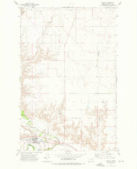 1972 Nashua1976 Print · USGSValley County in the early seventies centers on Nashua, where the railroad meets the winding Milk River. Researchers can locate the High Sch, trace the Fort Peck Indian Reservation Boundary, and identify family landmarks like Ivy Coulee.
 - 1984 Map of Glasgow
 1984 Glasgow1984 Print · USGSNorthwestern Montana's river valleys and high plains are shown in the mid-1980s, centered on the hub of Glasgow. Genealogists and historians can trace the Burlington Northern line through riverside towns like Tampico and Nashua or explore the vast Fort Peck Indian Reservation.
End of results
Showing maps 1-7 of 7
Frequently asked questions
- What are the different types of historical maps available for Nashua?
- What is the oldest map of Nashua?
- Where can I purchase historical maps of Nashua for my home or office?
- Where can I download high-res historical maps of Nashua?
- Are there historical topographic maps available for Nashua?
- Is there historical aerial imagery available for Nashua?
- Where are historical maps of Nashua sourced from?