1900s (20th Century) Maps of Harlowton, Montana
Explore 4 historic maps of Harlowton from the 1900s (20th Century). These maps offer a rare glimpse into what life looked like during the 1900s — showing old roads, neighborhoods, homes, and landmarks that have changed or disappeared over time.
Whether you're researching your family's past, planning a metal detecting trip, or studying how Harlowton's landscape evolved across the 1900s, these high-resolution maps are a powerful tool for exploring the history of this region.
- Focus on a specific era: All maps on this page are from the 1900s, giving you a focused view of this time period.
- See what’s changed: Compare century-old streets, trails, and buildings to today's modern landscape using overlays and satellite layers.
- Research with precision: Use these maps for genealogy, historical research, land use analysis, or educational projects.
- View, download, or print: Maps are fully viewable online in high resolution, and can be downloaded or printed for your own records.
Start exploring Harlowton's history through authentic maps from the 1900s. This is your window into the past.
Harlowton, MT maps
(4)- 1954 Map of Roundup, 1966 Print
 1954 Roundup1966 Print · USGSCentral Montana in the mid-1960s showcases a landscape of high-plains agriculture and vital rail connections. Researchers can trace historic routes through Harlowton and Roundup while locating landmarks like Judith Cemetery and Deadmans Basin Reservoir.2 unique versions available
 - 1958 Map of Roundup
 1958 Roundup1958 Print · USGSCentral Montana ranching and rail infrastructure are captured here in the late fifties as the Musselshell River valley thrived. Researchers can trace the Great Northern line through Harlowton or locate the Judith Cemetery and Gage Community.2 unique versions available
 - 1986 Map of Harlowton
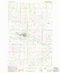 1986 Harlowton1986 Print · USGSWheatland County in the mid-1980s reveals a landscape shaped by the Musselshell River and early rail routes. Researchers can trace the Old Railroad Grade past Harlowton to outlying spots like Twodot and the Springwater Colony.
 - 1993 Map of Harlowton
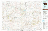 1993 Harlowton1993 Print · USGSCentral Montana's river valleys and high plains are captured here in the 1990s as the agricultural landscape evolved. Genealogists can trace family holdings near Springwater Colony or follow the Old Railroad Grade through Harlowton and Shawmut.
End of results
Showing maps 1-4 of 4
Frequently asked questions
- What are the different types of historical maps available for Harlowton?
- What is the oldest map of Harlowton?
- Where can I purchase historical maps of Harlowton for my home or office?
- Where can I download high-res historical maps of Harlowton?
- Are there historical topographic maps available for Harlowton?
- Is there historical aerial imagery available for Harlowton?
- Where are historical maps of Harlowton sourced from?