1900s (20th Century) Maps of Royal, Nebraska
Explore 7 historic maps of Royal from the 1900s (20th Century). These maps offer a rare glimpse into what life looked like during the 1900s — showing old roads, neighborhoods, homes, and landmarks that have changed or disappeared over time.
Whether you're researching your family's past, planning a metal detecting trip, or studying how Royal's landscape evolved across the 1900s, these high-resolution maps are a powerful tool for exploring the history of this region.
- Focus on a specific era: All maps on this page are from the 1900s, giving you a focused view of this time period.
- See what’s changed: Compare century-old streets, trails, and buildings to today's modern landscape using overlays and satellite layers.
- Research with precision: Use these maps for genealogy, historical research, land use analysis, or educational projects.
- View, download, or print: Maps are fully viewable online in high resolution, and can be downloaded or printed for your own records.
Start exploring Royal's history through authentic maps from the 1900s. This is your window into the past.
Royal, NE maps
(7)- 1955 Map of O'Neill, 1974 Print
 1955 O'Neill1974 Print · USGSNorth-central Nebraska in the 1950s reveals a vast cattle-ranching landscape transitioning from the Missouri River breaks to the iconic Sand Hills. Researchers can trace the path of the Chicago and North Western rail line and locate rural landmarks like the Dustin Post Office and St Johns Lake Ch.2 unique versions available
 - 1959 Map of O'Neill
 1959 O'Neill1959 Print · USGSNorth-central Nebraska in the late fifties is defined by the vast Sand Hills and the vital Chicago and North Western rail line. Genealogists and researchers can trace family roots through settlements like Atkinson, Bassett, and Stuart or follow the waters of the Niobrara River.2 unique versions available
 - 1963 Map of Royal, 1964 Print
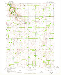 1963 Royal1964 Print · USGSThe village of Royal and its surrounding townships are shown here in the early sixties, anchored by the Chicago and North Western railroad. Genealogists can locate Royal Cem and several rural schoolhouses like Sunny Side Sch and Hollylodge Sch.3 unique versions available
 - 1963 Map of Orchard, 1964 Print
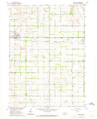 1963 Orchard1964 Print · USGSAntelope County in the early 1960s shows a landscape defined by the straight rails of the Chicago Burlington and Quincy. Genealogists can locate family landmarks at Orchard Cem, Highland Sch, and the small settlement of Royal.2 unique versions available
 - 1969 Map of O'Neill
 1969 O'Neill1969 Print · USGSCentral Nebraska in the mid-fifties is defined here by the expansive Sand Hills and the winding Niobrara River. Trace the Chicago and North Western rail line through cattle towns like O'Neill and Ainsworth.
 - 1985 Map of O'Neill
 1985 O'Neill1985 Print · USGSThe Elkhorn River valley and its surrounding plains are captured in the mid-1980s, showing a landscape defined by rail lines and ranching hubs. Genealogists and local historians can trace the rail networks of the Chicago and North Western and find smaller locales like Knievels Corner, Amelia, and Venus.2 unique versions available
 - 1989 Map of O'Neill
 1989 O'Neill1989 Print · USGSThe Nebraska-South Dakota borderlands are captured here in the late eighties, documenting the ranching and rail infrastructure of the High Plains. Genealogists and collectors can trace historic prairie towns like Monowi, Pishelville, and Santee along the Niobrara River.
End of results
Showing maps 1-7 of 7
Top cities near Royal
- Neligh historical maps
- Creighton historical maps
- Ewing historical maps
- Clearwater historical maps
- Orchard historical maps
- Brunswick historical maps
See more
Frequently asked questions
- What are the different types of historical maps available for Royal?
- What is the oldest map of Royal?
- Where can I purchase historical maps of Royal for my home or office?
- Where can I download high-res historical maps of Royal?
- Are there historical topographic maps available for Royal?
- Is there historical aerial imagery available for Royal?
- Where are historical maps of Royal sourced from?