1980s Maps of Velma, Nebraska
Explore 2 historic maps of Velma from the 1980s. These maps offer a rare glimpse into what life looked like during the 1980s — showing old roads, neighborhoods, homes, and landmarks that have changed or disappeared over time.
Whether you're researching your family's past, planning a metal detecting trip, or studying how Velma's landscape evolved across the 1980s, these high-resolution maps are a powerful tool for exploring the history of this region.
- Focus on a specific era: All maps on this page are from the 1980s, giving you a focused view of this time period.
- See what’s changed: Compare century-old streets, trails, and buildings to today's modern landscape using overlays and satellite layers.
- Research with precision: Use these maps for genealogy, historical research, land use analysis, or educational projects.
- View, download, or print: Maps are fully viewable online in high resolution, and can be downloaded or printed for your own records.
Start exploring Velma's history through authentic maps from the 1980s. This is your window into the past.
Velma, NE maps
(2)- 1985 Map of Arthur
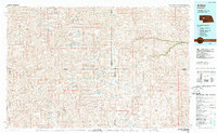 1985 Arthur1985 Print · USGSThe Nebraska Sandhills in the mid-1980s reveal a landscape of remote cattle ranches and hidden basins between Arthur and Hyannis. Genealogists and historians can trace family-named landmarks and private airfields like the Pioneer Ranch Landing Strip and Haythorn Lake.2 unique versions available
 - 1986 Map of Bourquim Hill
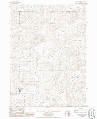 1986 Bourquim Hill1986 Print · USGSThe Nebraska Sandhills come into focus in the mid-1980s at the junction of Arthur, Garden, and Grant counties. Genealogists and historians can locate family ranching landmarks like the F Lane Ranch and isolated water points like Cocklebur Windmill.
End of results
Showing maps 1-2 of 2
Frequently asked questions
- What are the different types of historical maps available for Velma?
- What is the oldest map of Velma?
- Where can I purchase historical maps of Velma for my home or office?
- Where can I download high-res historical maps of Velma?
- Are there historical topographic maps available for Velma?
- Is there historical aerial imagery available for Velma?
- Where are historical maps of Velma sourced from?