1970s Maps of Ogallala, Nebraska
Explore 2 historic maps of Ogallala from the 1970s. These maps offer a rare glimpse into what life looked like during the 1970s — showing old roads, neighborhoods, homes, and landmarks that have changed or disappeared over time.
Whether you're researching your family's past, planning a metal detecting trip, or studying how Ogallala's landscape evolved across the 1970s, these high-resolution maps are a powerful tool for exploring the history of this region.
- Focus on a specific era: All maps on this page are from the 1970s, giving you a focused view of this time period.
- See what’s changed: Compare century-old streets, trails, and buildings to today's modern landscape using overlays and satellite layers.
- Research with precision: Use these maps for genealogy, historical research, land use analysis, or educational projects.
- View, download, or print: Maps are fully viewable online in high resolution, and can be downloaded or printed for your own records.
Start exploring Ogallala's history through authentic maps from the 1970s. This is your window into the past.
Ogallala, NE maps
(2)- 1971 Map of Ogallala SW, 1973 Print
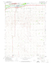 1971 Ogallala SW1973 Print · USGSSouthern Keith County and northern Perkins County are captured here in the early seventies as the High Plains landscape balanced agriculture and new infrastructure. Researchers can locate vanished rural landmarks such as School No 21, the Cornelius Landing Strip, and the winding Happy Hollow.
 - 1971 Map of Ogallala, 1974 Print
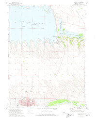 1971 Ogallala1974 Print · USGSOgallala and the neighboring river valleys are shown in detail during the early seventies. Genealogists and historians can trace the town's footprint, from the legendary Boot Hill Cem to the local High Sch and the Union Pacific rail lines.
End of results
Showing maps 1-2 of 2
Top cities near Ogallala
Frequently asked questions
- What are the different types of historical maps available for Ogallala?
- What is the oldest map of Ogallala?
- Where can I purchase historical maps of Ogallala for my home or office?
- Where can I download high-res historical maps of Ogallala?
- Are there historical topographic maps available for Ogallala?
- Is there historical aerial imagery available for Ogallala?
- Where are historical maps of Ogallala sourced from?