1960s Maps of Platte County, Nebraska
Explore 9 historic maps of Platte County from the 1960s. These maps offer a rare glimpse into what life looked like during the 1960s — showing old roads, neighborhoods, homes, and landmarks that have changed or disappeared over time.
Whether you're researching your family's past, planning a metal detecting trip, or studying how Platte County's landscape evolved across the 1960s, these high-resolution maps are a powerful tool for exploring the history of this region.
- Focus on a specific era: All maps on this page are from the 1960s, giving you a focused view of this time period.
- See what’s changed: Compare century-old streets, trails, and buildings to today's modern landscape using overlays and satellite layers.
- Research with precision: Use these maps for genealogy, historical research, land use analysis, or educational projects.
- View, download, or print: Maps are fully viewable online in high resolution, and can be downloaded or printed for your own records.
Start exploring Platte County's history through authentic maps from the 1960s. This is your window into the past.
Platte County, NE maps
(9)- 1966 Map of Newman Grove, 1967 Print
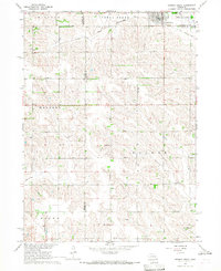 1966 Newman Grove1967 Print · USGSNewman Grove and the surrounding farmsteads of Madison and Platte counties are captured here in the mid-1960s. Researchers can trace the Chicago and North Western line, locate the Happy Hill Sch, or find family roots at Salem Ch.2 unique versions available
 - 1966 Map of Tarnov, 1967 Print
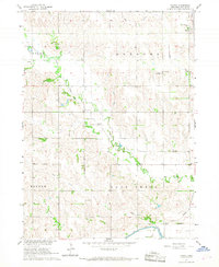 1966 Tarnov1967 Print · USGSAgricultural Platte County comes to life in the mid-sixties, showing the rural townships of Joliet and Burrows at a peak of traditional development. Genealogists can locate specific parish sites like St Anthonys Ch and numerous burying grounds including Burrows Cem and Zion Cem.2 unique versions available
 - 1966 Map of Lindsay SW, 1967 Print
 1966 Lindsay SW1967 Print · USGSThe Platte and Nance County line area in the mid-sixties is mapped here along the historic Old Indian Treaty Boundary. Genealogists can locate family landmarks like Bethany Ch Cem, Palestine Ch, and several rural schoolhouses.2 unique versions available
 - 1966 Map of Platte Center, 1967 Print
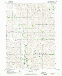
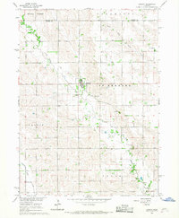
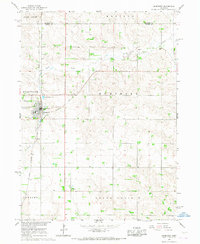
 1966 Platte Center1967 Print · USGSMid-century Platte County is captured here during a period of steady agricultural life, centered on the railroad corridor and the winding Shell Creek. Genealogists and local historians can locate early landmarks like Stretter Cem, School No 12, and the settlement of Tarnov.
 - 1966 Map of Lindsay, 1967 Print
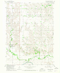
 1966 Lindsay1967 Print · USGSLindsay and the surrounding Platte County townships are captured here in the mid-1960s, showing a landscape of fertile creek bottoms and scattered prairie settlements. Genealogists can locate family landmarks like Looking Glass Sch and the Holy Family Cem.2 unique versions available
 - 1966 Map of Humphrey SE, 1968 Print
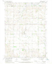
 1966 Humphrey SE1968 Print · USGSThe rural townships of Platte County come into focus in the 1960s, showing the agricultural heart of the Nebraska plains. Genealogists can locate family landmarks like St Johns Ch, Calvary Cem, and several numbered country schools.
 - 1966 Map of Creston, 1968 Print
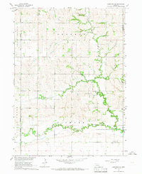
 1966 Creston1968 Print · USGSThe village of Creston and the surrounding farmlands are captured in the mid-1960s at the intersection of four Nebraska counties. Researchers can trace rural landmarks including the Old Railroad Grade, Creston Pioneer Cem, and Boheet Sch.
 - 1966 Map of Cornlea, 1968 Print
 1966 Cornlea1968 Print · USGSPlatte and Madison counties are captured here in the mid-sixties, centered on the settlement of Cornlea. Genealogists can locate the Sacred Heart Cem and Moriah Cem, or trace the path of the Old Railroad Grade across the prairie.2 unique versions available
 - 1966 Map of Humphrey, 1968 Print
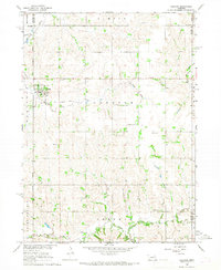
 1966 Humphrey1968 Print · USGSThe agricultural heart of Platte County is captured here in the mid-1960s as it transitions toward modern farming. Genealogists and local historians can trace family locations near St Francis Cem, the rural St Marys Ch, and the Union Pacific corridor.2 unique versions available
End of results
Showing maps 1-9 of 9
Top cities of Platte County
- Columbus historical maps
- Humphrey historical maps
- Oconee historical maps
- Platte Center historical maps
- Duncan historical maps
- Monroe historical maps
See more
Frequently asked questions
- What are the different types of historical maps available for Platte County?
- What is the oldest map of Platte County?
- Where can I purchase historical maps of Platte County for my home or office?
- Where can I download high-res historical maps of Platte County?
- Are there historical topographic maps available for Platte County?
- Is there historical aerial imagery available for Platte County?
- Where are historical maps of Platte County sourced from?