1980s Maps of Joder, Bowen Precinct
Explore 2 historic maps of Joder from the 1980s. These maps offer a rare glimpse into what life looked like during the 1980s — showing old roads, neighborhoods, homes, and landmarks that have changed or disappeared over time.
Whether you're researching your family's past, planning a metal detecting trip, or studying how Joder's landscape evolved across the 1980s, these high-resolution maps are a powerful tool for exploring the history of this region.
- Focus on a specific era: All maps on this page are from the 1980s, giving you a focused view of this time period.
- See what’s changed: Compare century-old streets, trails, and buildings to today's modern landscape using overlays and satellite layers.
- Research with precision: Use these maps for genealogy, historical research, land use analysis, or educational projects.
- View, download, or print: Maps are fully viewable online in high resolution, and can be downloaded or printed for your own records.
Start exploring Joder's history through authentic maps from the 1980s. This is your window into the past.
Joder, Bowen Precinct maps
(2)- 1980 Map of Roundtop, 1981 Print
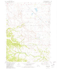 1980 Roundtop1981 Print · USGSWestern Nebraska rangeland in the late seventies is captured here within the Oglala National Grassland and along the Sioux and Dawes County border. Researchers can locate remote rural institutions and landmarks like Union Star Cem, Roundtop Sch, and Toadstool Park.
 - 1986 Map of Crawford
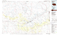 1986 Crawford1986 Print · USGSThe Nebraska Panhandle in the mid-eighties shows a high-plains landscape defined by its rugged geology and major rail corridors. Genealogists and historians can trace the paths of the Burlington Northern railroad through settlements like Orella, Glen, and Harrison.2 unique versions available
End of results
Showing maps 1-2 of 2
Top cities near Joder
Frequently asked questions
- What are the different types of historical maps available for Joder?
- What is the oldest map of Joder?
- Where can I purchase historical maps of Joder for my home or office?
- Where can I download high-res historical maps of Joder?
- Are there historical topographic maps available for Joder?
- Is there historical aerial imagery available for Joder?
- Where are historical maps of Joder sourced from?