Old Maps of Lake Village, Douglas County for Genealogy
Trace your family roots with 12 historic maps of Lake Village. These high-res maps reveal old neighborhoods, homesites, landmarks, and streets — helping you uncover where your ancestors lived and how the area evolved over time.
- Explore historic neighborhoods: Identify where your relatives may have lived in the 1800s or 1900s.
- Compare maps over time: Trace the changes in streets, buildings, and landmarks for multi-generational research.
- Perfect for genealogy & ancestry research: Used by family historians and researchers to map out lineage and migration.
These maps are an incredible resource for exploring your personal connection to Lake Village's past.
Lake Village, Douglas County maps
(12)- 1889 Map of Markleeville, 1954 Print
 1889 Markleeville1954 Print · USGSCovers Lake Village, including South Lake Tahoe, Gardnerville Ranchos, and other nearby areas
 - 1891 Map of Markleeville
 1891 Markleeville1891 Print · USGSCovers Lake Village, including South Lake Tahoe, Gardnerville Ranchos, and other nearby areas
 - 1893 Map of Markleeville
 1893 Markleeville1893 Print · USGSCovers Lake Village, including South Lake Tahoe, Gardnerville Ranchos, and other nearby areas9 unique versions available
 - 1948 Map of Walker Lake
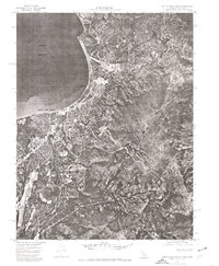
 1948 Walker Lake1948 Print · USGSCovers Lake Village, including South Lake Tahoe, Gardnerville Ranchos, and other nearby areas2 unique versions available
 - 1955 Map of Bijou, 1957 Print
 1955 Bijou1957 Print · USGSCovers Lake Village, including South Lake Tahoe, Kingsbury, and other nearby areas7 unique versions available
 - 1956 Map of Freel Peak, 1958 Print
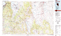
 1956 Freel Peak1958 Print · USGSCovers Lake Village, including South Lake Tahoe, Minden, and other nearby areas3 unique versions available
 - 1957 Map of Walker Lake
 1957 Walker Lake1957 Print · USGSCovers Lake Village, including South Lake Tahoe, Gardnerville Ranchos, and other nearby areas4 unique versions available
 - 1962 Map of Walker Lake
 1962 Walker Lake1962 Print · USGSCovers Lake Village, including South Lake Tahoe, Gardnerville Ranchos, and other nearby areas
 - 1964 Map of Walker Lake
 1964 Walker Lake1964 Print · USGSCovers Lake Village, including South Lake Tahoe, Gardnerville Ranchos, and other nearby areas2 unique versions available
 - 1974 Map of South Lake Tahoe, 1977 Print
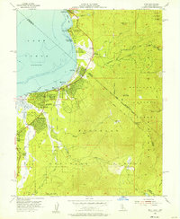
 1974 South Lake Tahoe1977 Print · USGSCovers Lake Village, including South Lake Tahoe, Kingsbury, and other nearby areas
 - 1985 Map of Smith Valley
 1985 Smith Valley1985 Print · USGSCovers Lake Village, including South Lake Tahoe, Gardnerville Ranchos, and other nearby areas2 unique versions available
 - 1992 Map of South Lake Tahoe, 1994 Print
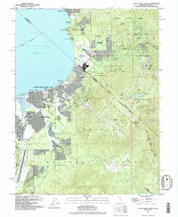 1992 South Lake Tahoe1994 Print · USGSCovers Lake Village, including South Lake Tahoe, Kingsbury, and other nearby areas
End of results
Showing maps 1-12 of 12
Frequently asked questions
- What are the different types of historical maps available for Lake Village?
- What is the oldest map of Lake Village?
- Where can I purchase historical maps of Lake Village for my home or office?
- Where can I download high-res historical maps of Lake Village?
- Are there historical topographic maps available for Lake Village?
- Is there historical aerial imagery available for Lake Village?
- Where are historical maps of Lake Village sourced from?