1980s Maps of Contact, Nevada
Explore 2 historic maps of Contact from the 1980s. These maps offer a rare glimpse into what life looked like during the 1980s — showing old roads, neighborhoods, homes, and landmarks that have changed or disappeared over time.
Whether you're researching your family's past, planning a metal detecting trip, or studying how Contact's landscape evolved across the 1980s, these high-resolution maps are a powerful tool for exploring the history of this region.
- Focus on a specific era: All maps on this page are from the 1980s, giving you a focused view of this time period.
- See what’s changed: Compare century-old streets, trails, and buildings to today's modern landscape using overlays and satellite layers.
- Research with precision: Use these maps for genealogy, historical research, land use analysis, or educational projects.
- View, download, or print: Maps are fully viewable online in high resolution, and can be downloaded or printed for your own records.
Start exploring Contact's history through authentic maps from the 1980s. This is your window into the past.
Contact, NV maps
(2)- 1982 Map of Jackpot
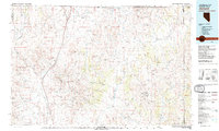 1982 Jackpot1982 Print · USGSThe high desert borderlands of Nevada, Idaho, and Utah are captured here in the early eighties as a hub of mining and transport. Researchers can locate remote operations like Gold Note Mine and trace the Union Pacific line past Delaplain.
 - 1989 Map of Contact
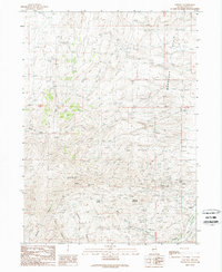 1989 Contact1989 Print · USGSThe high desert of northeastern Nevada is documented here during a period of active mineral exploration in the late eighties. Metal detectorists and mining historians can trace the locations of the Mammoth Mine, Marshall Mine, and the distinctive Old RR Grade.
End of results
Showing maps 1-2 of 2
Top cities near Contact
Frequently asked questions
- What are the different types of historical maps available for Contact?
- What is the oldest map of Contact?
- Where can I purchase historical maps of Contact for my home or office?
- Where can I download high-res historical maps of Contact?
- Are there historical topographic maps available for Contact?
- Is there historical aerial imagery available for Contact?
- Where are historical maps of Contact sourced from?