1980s Maps of Amos, Nevada
Explore 2 historic maps of Amos from the 1980s. These maps offer a rare glimpse into what life looked like during the 1980s — showing old roads, neighborhoods, homes, and landmarks that have changed or disappeared over time.
Whether you're researching your family's past, planning a metal detecting trip, or studying how Amos's landscape evolved across the 1980s, these high-resolution maps are a powerful tool for exploring the history of this region.
- Focus on a specific era: All maps on this page are from the 1980s, giving you a focused view of this time period.
- See what’s changed: Compare century-old streets, trails, and buildings to today's modern landscape using overlays and satellite layers.
- Research with precision: Use these maps for genealogy, historical research, land use analysis, or educational projects.
- View, download, or print: Maps are fully viewable online in high resolution, and can be downloaded or printed for your own records.
Start exploring Amos's history through authentic maps from the 1980s. This is your window into the past.
Amos, NV maps
(2)- 1982 Map of Andorno Ranch
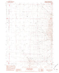 1982 Andorno Ranch1982 Print · USGSHumboldt County ranching life in the early 1980s is centered around isolated outposts and the vital water of the Quinn River Valley. Genealogists and historians can trace the footprints of Andorno Ranch, Barber Ranch, and the irrigation networks of the Int Ditch.
 - 1985 Map of Osgood Mts
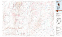 1985 Osgood Mts1985 Print · USGSHumboldt County in the mid-eighties was a hub of high-desert mining and remote ranching outposts. Trace the industrial footprint of the Getchell Mine, locate historic settlements like Amos, and follow the rail lines through Winnemucca.
End of results
Showing maps 1-2 of 2
Top cities near Amos
Frequently asked questions
- What are the different types of historical maps available for Amos?
- What is the oldest map of Amos?
- Where can I purchase historical maps of Amos for my home or office?
- Where can I download high-res historical maps of Amos?
- Are there historical topographic maps available for Amos?
- Is there historical aerial imagery available for Amos?
- Where are historical maps of Amos sourced from?