1980s Maps of Mellan, Nevada
Explore 2 historic maps of Mellan from the 1980s. These maps offer a rare glimpse into what life looked like during the 1980s — showing old roads, neighborhoods, homes, and landmarks that have changed or disappeared over time.
Whether you're researching your family's past, planning a metal detecting trip, or studying how Mellan's landscape evolved across the 1980s, these high-resolution maps are a powerful tool for exploring the history of this region.
- Focus on a specific era: All maps on this page are from the 1980s, giving you a focused view of this time period.
- See what’s changed: Compare century-old streets, trails, and buildings to today's modern landscape using overlays and satellite layers.
- Research with precision: Use these maps for genealogy, historical research, land use analysis, or educational projects.
- View, download, or print: Maps are fully viewable online in high resolution, and can be downloaded or printed for your own records.
Start exploring Mellan's history through authentic maps from the 1980s. This is your window into the past.
Mellan, NV maps
(2)- 1988 Map of Mellan
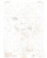 1988 Mellan1988 Print · USGSNye County's high-desert terrain is shown here during the late 1980s, revealing a landscape defined by restricted military use and early mining. Trace the remnants of local industry at Mellan and its nearby Mine Shafts, or locate the remote Mellan Airstrip on the edge of Cactus Flat.
 - 1988 Map of Cactus Flat, 1989 Print
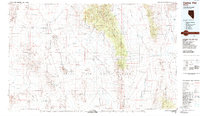 1988 Cactus Flat1989 Print · USGSNye County in the late eighties reveals a stark desert landscape where military operations overlap with old mining history. Researchers can trace the layout of early camps like Silverbow and Jamestown alongside the deep Kawich Depression.
End of results
Showing maps 1-2 of 2
Frequently asked questions
- What are the different types of historical maps available for Mellan?
- What is the oldest map of Mellan?
- Where can I purchase historical maps of Mellan for my home or office?
- Where can I download high-res historical maps of Mellan?
- Are there historical topographic maps available for Mellan?
- Is there historical aerial imagery available for Mellan?
- Where are historical maps of Mellan sourced from?