1900s (20th Century) Maps of Mercury, Nevada
Explore 10 historic maps of Mercury from the 1900s (20th Century). These maps offer a rare glimpse into what life looked like during the 1900s — showing old roads, neighborhoods, homes, and landmarks that have changed or disappeared over time.
Whether you're researching your family's past, planning a metal detecting trip, or studying how Mercury's landscape evolved across the 1900s, these high-resolution maps are a powerful tool for exploring the history of this region.
- Focus on a specific era: All maps on this page are from the 1900s, giving you a focused view of this time period.
- See what’s changed: Compare century-old streets, trails, and buildings to today's modern landscape using overlays and satellite layers.
- Research with precision: Use these maps for genealogy, historical research, land use analysis, or educational projects.
- View, download, or print: Maps are fully viewable online in high resolution, and can be downloaded or printed for your own records.
Start exploring Mercury's history through authentic maps from the 1900s. This is your window into the past.
Mercury, NV maps
(10)- 1907 Map of Las Vegas, 1956 Print
 1907 Las Vegas1956 Print · USGSSouthern Nevada is shown at a pivotal moment in the early 1900s as the rail network began to transform the desert landscape. Genealogists and historians can locate early homesteads and landmarks like Las Vegas Ranch, Mormon Well, and the Stirling Mine.
 - 1908 Map of Las Vegas
 1908 Las Vegas1908 Print · USGSSouthern Nevada was a frontier of rail and ranching in the years before major desert expansion. Trace the early footprints of Las Vegas and its surrounding outposts like Arden, Bracken, and the Stirling Mine.4 unique versions available
 - 1942 Map of Indian Spring
 1942 Indian Spring1942 Print · USGSSouthern Nevada's desert landscape is captured here in the early forties as military interests began to redefine the territory. Researchers can trace the early layout of Indian Spring and find remote water sources like Quartz Spring and Mesquite Spring.
 - 1952 Map of Mercury, 1958 Print
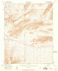 1952 Mercury1958 Print · USGSThe Nevada desert in the early fifties shows the high-security infrastructure of the atomic age. Historians can trace the original layout of Mercury and follow the path of the Mercury Highway as it climbs through Checkpoint Pass.2 unique versions available
 - 1954 Map of Las Vegas
 1954 Las Vegas1954 Print · USGSLas Vegas and the Mojave Desert are shown in the early fifties as the region's military and recreational footprint expanded. Genealogists and historians can trace the early layout of North Las Vegas, the sites of Indian Springs Air Force Base, and long-established towns like Bunkerville.5 unique versions available
 - 1957 Map of Las Vegas
 1957 Las Vegas1957 Print · USGSSouthern Nevada in the mid-fifties is a landscape of massive federal ranges and the early growth of Las Vegas. Researchers can trace the development of McCarran Field, the expansive Lake Mead National Recreation Area, and the industrial footprint of Henderson.
 - 1959 Map of Las Vegas
 1959 Las Vegas1959 Print · USGSSouthern Nevada in the late fifties was a landscape of rapid suburban growth and massive federal installations. Genealogists and historians can trace early housing at Victory Village, the grounds of Camp Desert Rock, and the remote Tule Springs Ranch.
 - 1961 Map of Mercury, 1962 Print
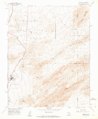 1961 Mercury1962 Print · USGSThe base camp at Mercury and the Nevada Test Site appear here during the height of the early 1960s. Researchers can trace military infrastructure from Checkpoint Pass to the Eagle Roost Radio Tower and the Ranger Mountains.3 unique versions available
 - 1962 Map of Las Vegas
 1962 Las Vegas1962 Print · USGSSouthern Nevada is captured here during a period of significant military and industrial growth in the early sixties. Researchers can trace the development of Las Vegas alongside the Magnesium Plant in Henderson and the expansive Nellis Air Force Base.
 - 1988 Map of Indian Springs
 1988 Indian Springs1988 Print · USGSIn the late 1980s, the high desert north of Las Vegas was a complex landscape of military testing grounds and wildlife preserves. Researchers can trace the boundaries of the Nellis Air Force Range alongside landmarks like Indian Springs, Frenchman Lake, and the remote Yucca Forest.
End of results
Showing maps 1-10 of 10
Frequently asked questions
- What are the different types of historical maps available for Mercury?
- What is the oldest map of Mercury?
- Where can I purchase historical maps of Mercury for my home or office?
- Where can I download high-res historical maps of Mercury?
- Are there historical topographic maps available for Mercury?
- Is there historical aerial imagery available for Mercury?
- Where are historical maps of Mercury sourced from?