1970s Maps of Bean's Purchase, New Hampshire
Explore 2 historic maps of Bean's Purchase from the 1970s. These maps offer a rare glimpse into what life looked like during the 1970s — showing old roads, neighborhoods, homes, and landmarks that have changed or disappeared over time.
Whether you're researching your family's past, planning a metal detecting trip, or studying how Bean's Purchase's landscape evolved across the 1970s, these high-resolution maps are a powerful tool for exploring the history of this region.
- Focus on a specific era: All maps on this page are from the 1970s, giving you a focused view of this time period.
- See what’s changed: Compare century-old streets, trails, and buildings to today's modern landscape using overlays and satellite layers.
- Research with precision: Use these maps for genealogy, historical research, land use analysis, or educational projects.
- View, download, or print: Maps are fully viewable online in high resolution, and can be downloaded or printed for your own records.
Start exploring Bean's Purchase's history through authentic maps from the 1970s. This is your window into the past.
Bean's Purchase, NH maps
(2)- 1970 Map of Wild River, 1972 Print
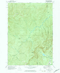 1970 Wild River1972 Print · USGSThe New Hampshire and Maine borderlands are shown here in the early 1970s, focused on the drainage of the Wild River. Trace the high-country Appalachian Trail and find backcountry landmarks like the Spruce Brook Shelter and Brickett Place.3 unique versions available
 - 1970 Map of Carter Dome, 1972 Print
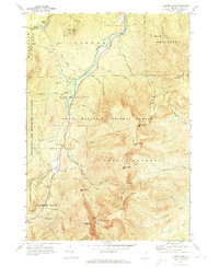 1970 Carter Dome1972 Print · USGSCoos County, New Hampshire, is captured here in the early 1970s as its peaks became central to Eastern mountaineering and recreation. Researchers can trace the legendary Appalachian Trail, the historic Glen House site, and the high-altitude Carter Notch trails.3 unique versions available
End of results
Showing maps 1-2 of 2
Top cities near Bean's Purchase
- Berlin historical maps
- Conway historical maps
- Fryeburg historical maps
- Bartlett historical maps
- Gorham historical maps
- Lovell historical maps
See more
Frequently asked questions
- What are the different types of historical maps available for Bean's Purchase?
- What is the oldest map of Bean's Purchase?
- Where can I purchase historical maps of Bean's Purchase for my home or office?
- Where can I download high-res historical maps of Bean's Purchase?
- Are there historical topographic maps available for Bean's Purchase?
- Is there historical aerial imagery available for Bean's Purchase?
- Where are historical maps of Bean's Purchase sourced from?