Old Maps of Campton, New Hampshire for Metal Detecting
Plan your next treasure hunt with 36 historic maps of Campton. Find old homesites, ghost towns, trails, and gathering spots that may be lost to time — perfect for identifying promising metal detecting locations.
- Locate forgotten sites: Uncover places like long-lost settlements, abandoned rail lines, or gathering spots.
- Plan better hunts: Use map overlays combined with LiDAR or satellite views to narrow in on historically rich areas.
- Made for detectorists: Thousands of hobbyists use these maps to discover relics, coins, and hidden history.
Use these historic maps to boost your research and find new opportunities beneath the surface of Campton.
Campton, NH maps
(36)- 1928 Map of Plymouth, 1953 Print
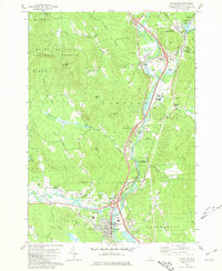
 1928 Plymouth1953 Print · USGSGrafton County is captured in the late 1920s as its river towns and mountain resorts began to modernize. Genealogists can trace family footprints at Blair Cemetery or locate old schoolhouses like Pulsifer Hill Sch and Thornton Center Sch along the valley roads.5 unique versions available
 - 1931 Map of Plymouth
 1931 Plymouth1931 Print · USGSGrafton County communities are linked by the Boston and Maine Railroad during the early thirties. Genealogists can trace family roots through numerous rural landmarks like Thornton Center, Blair Sch, and the riverside landings at Livermore Falls.5 unique versions available
 - 1949 Map of Portland
 1949 Portland1949 Print · USGSCoastal Maine and the New Hampshire interior are shown in detail during the late forties, from the bustling harbors to the lakeside villages. Researchers can trace historical rail networks like the Boston & Maine RR and locate coastal defenses such as Fort Preble.3 unique versions available
 - 1956 Map of Portland, 1963 Print
 1956 Portland1963 Print · USGSSouthern Maine and eastern New Hampshire are captured here in the mid-fifties, during a time of major highway expansion and military growth. You can trace the path of the Maine Turnpike and locate landmarks like the Portsmouth Naval Shipyard and Sebago Lake.4 unique versions available
 - 1959 Map of Portland
 1959 Portland1959 Print · USGSThe Maine and New Hampshire coastlines meet in this mid-century portrait of maritime commerce and inland rail networks. Researchers can trace the legacy of coastal defense at Fort Williams and follow the historic path of the Maine Central RR through the White Mountain National Forest.2 unique versions available
 - 1963 Map of Portland
 1963 Portland1963 Print · USGSCoastal Maine and New Hampshire thrived as maritime and industrial hubs during the mid-sixties, linked by a dense network of rail and river. Researchers can trace historic transit corridors like the Maine Central RR and locate key sites such as the Portsmouth Naval Shipyard or Pease Air Force Base.3 unique versions available
 - 1980 Map of Plymouth, 1981 Print
 1980 Plymouth1981 Print · USGSGrafton County's river valleys were well-established by the early 1980s, balancing local industry with institutional growth. Genealogists and historians can trace the foundations of Plymouth, locate the Holderness Sch, and find family plots at Blair Cem or the Townhall Campton Ch.2 unique versions available
 - 1980 Map of Squam Mountains, 1981 Print
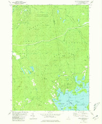 1980 Squam Mountains1981 Print · USGSThe Squam Lake shoreline and high peaks of the Sandwich Range define this central New Hampshire landscape in the early eighties. Genealogists and hikers can trace historical routes like the Sandwich Notch Road, the Old RR Grade, and localized landmarks including the Covered Bridge.2 unique versions available
 - 1980 Map of Waterville Valley, 1981 Print
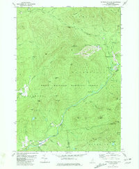 1980 Waterville Valley1981 Print · USGSWaterville Valley and the surrounding peaks of the White Mountains are captured here in the early 1980s as the recreation economy matured. Researchers can locate the Mad River Cem, trace the old Sandwich Notch Road, and identify historic bridges like Sixmile Bridge.3 unique versions available
 - 1980 Map of Woodstock, 1981 Print
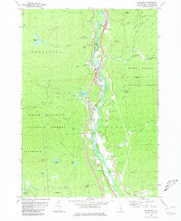 1980 Woodstock1981 Print · USGSGrafton County's river valley communities are documented here in the early eighties, showing the alignment of modern roads alongside traditional mountain settlements. You can locate family-history landmarks like Pine Grove Cem and Thornton Ch or trace the drainage of Mirror Lake into the Pemigewasset River.2 unique versions available
 - 1986 Map of Lake Winnipesaukee
 1986 Lake Winnipesaukee1986 Print · USGSThe Lakes Region in the mid-eighties shows a landscape of dense water bodies and mountain ranges at the peak of its twentieth-century character. Trace the legacy of old rail lines like the Boston and Maine RR and locate historic centers from Rumney Depot to Melvin Village.2 unique versions available
 - 1995 Map of Woodstock, 2000 Print
 1995 Woodstock2000 Print · USGSGrafton County's mountain valley is captured in the mid-1990s as the river-based communities of Woodstock and Thornton sit alongside preserved wildlands. Researchers can locate the Thornton School, Thornton Church, and Pine Grove Cemetery along the PEMIGEWASSET RIVER.
 - 1995 Map of Plymouth, 2000 Print
 1995 Plymouth2000 Print · USGSGrafton County life centered on the Pemigewasset River and Baker River in the mid-nineties, showing the region's mix of mountain forest and valley industry. Genealogists and historians can trace sites like Campton Hollow, Trinity Church, and the Blair Cemetery.
 - 1995 Map of Waterville Valley, 2000 Print
 1995 Waterville Valley2000 Print · USGSWaterville Valley and the surrounding peaks of the White Mountain National Forest are captured in the mid-1990s as a hub of both recreation and wilderness. Genealogists and hikers can trace the paths between the Mad River Cemetery, Goose Hollow, and the remote Greeley Pond.
 - 1995 Map of Squam Mountains, 2000 Print
 1995 Squam Mountains2000 Print · USGSThe Squam Mountains and northern lakeshore are captured here in the mid-1990s as hiking trails and summer colonies matured. Researchers can trace the Sandwich Notch Road, find the lakeside Rockywold settlement, and locate the historic Covered Bridge over the Beebe River.
 - 2012 Map of Plymouth, 2012 Print
 2012 Plymouth2012 Print · USGSCovers Campton, including Plymouth, Thornton, and other nearby areas
 - 2012 Map of Woodstock, 2012 Print
 2012 Woodstock2012 Print · USGSCovers Campton, including Thornton, Woodstock, and other nearby areas
 - 2012 Map of Waterville Valley, 2012 Print
 2012 Waterville Valley2012 Print · USGSCovers Campton, including Thornton, Sandwich, and other nearby areas
 - 2012 Map of Squam Mountains, 2012 Print
 2012 Squam Mountains2012 Print · USGSCovers Campton, including Moultonborough, Thornton, and other nearby areas
 - 2015 Map of Waterville Valley, 2015 Print
 2015 Waterville Valley2015 Print · USGSCovers Campton, including Thornton, Sandwich, and other nearby areas
 - 2015 Map of Plymouth, 2015 Print
 2015 Plymouth2015 Print · USGSCovers Campton, including Plymouth, Thornton, and other nearby areas
 - 2015 Map of Woodstock, 2015 Print
 2015 Woodstock2015 Print · USGSCovers Campton, including Thornton, Woodstock, and other nearby areas
 - 2015 Map of Squam Mountains, 2015 Print
 2015 Squam Mountains2015 Print · USGSCovers Campton, including Moultonborough, Thornton, and other nearby areas
 - 2018 Map of Waterville Valley, 2018 Print
 2018 Waterville Valley2018 Print · USGSCovers Campton, including Thornton, Sandwich, and other nearby areas
 - 2018 Map of Squam Mountains, 2018 Print
 2018 Squam Mountains2018 Print · USGSCovers Campton, including Moultonborough, Thornton, and other nearby areas
Showing maps 1-25 of 36
Top cities near Campton
- Laconia historical maps
- Gilford historical maps
- Moultonborough historical maps
- Plymouth historical maps
- Bristol historical maps
- Thornton historical maps
See more
Top neighborhoods of Campton
- Blair historical maps
- Campton Station historical maps
- Campton Upper Village historical maps
- West Campton historical maps
- Beebe River historical maps
- Campton Hollow historical maps
See more
Frequently asked questions
- What are the different types of historical maps available for Campton?
- What is the oldest map of Campton?
- Where can I purchase historical maps of Campton for my home or office?
- Where can I download high-res historical maps of Campton?
- Are there historical topographic maps available for Campton?
- Is there historical aerial imagery available for Campton?
- Where are historical maps of Campton sourced from?