Old Maps of Enfield, New Hampshire
Explore 33 old maps of Enfield, spanning from 1927 to today. These high-resolution historic maps reveal how streets, neighborhoods, landmarks, and natural features evolved over time — perfect for genealogy, metal detecting, research, and local history exploration.
What you can do with these maps:
- See how Enfield changed over time: Compare historical maps to modern-day views to trace roads, homesites, rail lines & more.
- View detailed metadata: Each map includes creators, publishers, year, scale, and archive source.
- Overlay maps with satellite & LiDAR: Visualize the past alongside modern tools to explore terrain & human change.
- Trusted historical sources: Maps sourced from the USGS, Library of Congress, and other archives.
- Access maps your way: View online, download high-res files, or order prints for personal or research use.
Start exploring old maps of Enfield to uncover forgotten places, hidden landmarks, and the deep history beneath your feet.
Enfield, NH maps
(33)- 1927 Map of Mascoma, 1957 Print
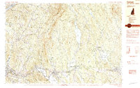
 1927 Mascoma1957 Print · USGSGrafton County's hill towns and valleys are caught in detail during the late 1920s, showing the settled character of the New Hampshire interior. Genealogists can trace family names through landmarks like Washburn Corner or locate the distinctive Lower Shaker Village and Upper Shaker Village.3 unique versions available
 - 1932 Map of Mascoma
 1932 Mascoma1932 Print · USGSGrafton County in the early thirties shows a unique landscape of communal settlements and rugged upland farms. Genealogists can trace family roots through numerous local schoolhouses and rural hamlets like Hanover Center and Lower Shaker Village.5 unique versions available
 - 1950 Map of Glens Falls
 1950 Glens Falls1950 Print · USGSThe Adirondacks and the Green Mountains meet in this mid-century survey of the New York and Vermont borderlands. Researchers can trace the industrial rail corridors of the Rutland RR and Delaware & Hudson RR connecting Glens Falls, Rutland, and the shores of Lake George.
 - 1956 Map of Glens Falls, 1968 Print
 1956 Glens Falls1968 Print · USGSUpper New York and the Vermont mountains are captured here in the mid-fifties, showing the rugged rail-and-river network of the Northeast. Researchers can trace the paths of the Delaware and Hudson RR and Rutland RR as they wind through valley towns like Poultney and Whitehall.3 unique versions available
 - 1959 Map of Glens Falls
 1959 Glens Falls1959 Print · USGSUpper New York and Vermont are captured here during the late 1950s, a period of transition for these mountain communities. Researchers can trace the legacy of the region's river-and-rail economy through landmarks like Lake George, Saratoga Springs, and Killington Peak.2 unique versions available
 - 1964 Map of Glens Falls
 1964 Glens Falls1964 Print · USGSThe tri-state borderlands of New York, Vermont, and New Hampshire appear here in the mid-1960s. Researchers can trace the rail routes of the Rutland RR and find historic sites like Ticonderoga and Saratoga National Historical Park.
 - 1984 Map of Canaan
 1984 Canaan1984 Print · USGSGrafton County in the early eighties shows a landscape of clustered village centers and emerging wildlife management areas. Genealogists and local historians can trace family roots through the settlements of Canaan Street, Hanover Center, and the historic Shaker Hill district.3 unique versions available
 - 1984 Map of Enfield Center
 1984 Enfield Center1984 Print · USGSThe Shaker heritage and rural highlands of Grafton County are documented here in the mid-1980s. Genealogists and historians can locate family landmarks like Purmort Cem, the historic Lower Shaker Village, and the site of the Fish Market.2 unique versions available
 - 1985 Map of Rutland, 1988 Print
 1985 Rutland1988 Print · USGSThe Upper Valley of the mid-1980s comes to life along the winding Connecticut River as it divides the Green Mountain and Granite states. Historians can trace the industrial rail hubs of White River Junction and the paths of the Appalachian Trail and Long Trail.
 - 1995 Map of Canaan, 2001 Print
 1995 Canaan2001 Print · USGSGrafton County near the end of the twentieth century shows a region of tightly knit lakeside villages and protected forests. Genealogists and local historians can trace the roads connecting Canaan Center to Canaan Street and locate family sites near Cobble Cemetery.
 - 1996 Map of Enfield, 2001 Print
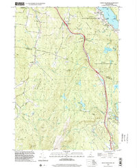
 1996 Enfield2001 Print · USGSGrafton County during the mid-1990s shows a landscape defined by the rise of Moose Mountain and the sprawling waters of Mascoma Lake. Researchers can trace the heritage of Enfield near the Shaker Bridge or follow the Appalachian Trail through the high woods of the White Mountain National Forest.
 - 1998 Map of North Grantham, 2002 Print
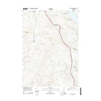
 1998 North Grantham2002 Print · USGSSullivan and Grafton Counties in the late nineties show a landscape where historic communal settlements meet modern transportation corridors. Researchers can trace the heritage of Lower Shaker Village, locate the Gleason Cem, or explore the wooded heights of Methodist Hill.
 - 1998 Map of Enfield Center, 2002 Print
 1998 Enfield Center2002 Print · USGSGrafton County's hill country near the Sullivan County line is captured here in the late nineties, showing a landscape of forest reserves and glacial lakes. Genealogists and locals can trace family landmarks and rural crossroads like Washburn Corner, Crystal Lake Dam Lockehaven, and Banks Pinnacle.
 - 2012 Map of Enfield Center, 2012 Print
 2012 Enfield Center2012 Print · USGSCovers Enfield, including Grantham, Grafton, and other nearby areas
 - 2012 Map of North Grantham, 2012 Print
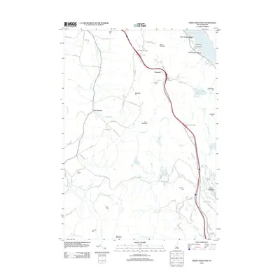 2012 North Grantham2012 Print · USGSCovers Enfield, including Lebanon, Grantham, and other nearby areas
 - 2012 Map of Canaan, 2012 Print
 2012 Canaan2012 Print · USGSCovers Enfield, including Hanover, Lyme, and other nearby areas
 - 2012 Map of Enfield, 2012 Print
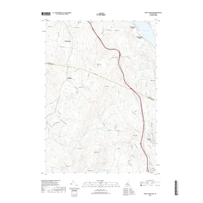
 2012 Enfield2012 Print · USGSCovers Enfield, including Lebanon, Hanover, and other nearby areas
 - 2015 Map of Enfield Center, 2015 Print
 2015 Enfield Center2015 Print · USGSCovers Enfield, including Grantham, Grafton, and other nearby areas
 - 2015 Map of North Grantham, 2015 Print
 2015 North Grantham2015 Print · USGSCovers Enfield, including Lebanon, Grantham, and other nearby areas
 - 2015 Map of Canaan, 2015 Print
 2015 Canaan2015 Print · USGSCovers Enfield, including Hanover, Lyme, and other nearby areas
 - 2015 Map of Enfield, 2015 Print
 2015 Enfield2015 Print · USGSCovers Enfield, including Lebanon, Hanover, and other nearby areas
 - 2018 Map of North Grantham, 2018 Print
 2018 North Grantham2018 Print · USGSCovers Enfield, including Lebanon, Grantham, and other nearby areas
 - 2018 Map of Canaan, 2018 Print
 2018 Canaan2018 Print · USGSCovers Enfield, including Hanover, Lyme, and other nearby areas
 - 2018 Map of Enfield Center, 2018 Print
 2018 Enfield Center2018 Print · USGSCovers Enfield, including Grantham, Grafton, and other nearby areas
 - 2018 Map of Enfield, 2018 Print
 2018 Enfield2018 Print · USGSCovers Enfield, including Lebanon, Hanover, and other nearby areas
Showing maps 1-25 of 33
Top cities near Enfield
- Lebanon historical maps
- Claremont historical maps
- Hanover historical maps
- Hartford historical maps
- Newport historical maps
- New London historical maps
See more
Top neighborhoods of Enfield
- Enfield Center historical maps
- Lockehaven historical maps
- Montcalm historical maps
- Lower Shaker Village historical maps
- Upper Shaker Village historical maps
- Enfield Shaker Historic District historical maps
Frequently asked questions
- What are the different types of historical maps available for Enfield?
- What is the oldest map of Enfield?
- Where can I purchase historical maps of Enfield for my home or office?
- Where can I download high-res historical maps of Enfield?
- Are there historical topographic maps available for Enfield?
- Is there historical aerial imagery available for Enfield?
- Where are historical maps of Enfield sourced from?