1990s Maps of Enfield, New Hampshire
Explore 4 historic maps of Enfield from the 1990s. These maps offer a rare glimpse into what life looked like during the 1990s — showing old roads, neighborhoods, homes, and landmarks that have changed or disappeared over time.
Whether you're researching your family's past, planning a metal detecting trip, or studying how Enfield's landscape evolved across the 1990s, these high-resolution maps are a powerful tool for exploring the history of this region.
- Focus on a specific era: All maps on this page are from the 1990s, giving you a focused view of this time period.
- See what’s changed: Compare century-old streets, trails, and buildings to today's modern landscape using overlays and satellite layers.
- Research with precision: Use these maps for genealogy, historical research, land use analysis, or educational projects.
- View, download, or print: Maps are fully viewable online in high resolution, and can be downloaded or printed for your own records.
Start exploring Enfield's history through authentic maps from the 1990s. This is your window into the past.
Enfield, NH maps
(4)- 1995 Map of Canaan, 2001 Print
 1995 Canaan2001 Print · USGSGrafton County near the end of the twentieth century shows a region of tightly knit lakeside villages and protected forests. Genealogists and local historians can trace the roads connecting Canaan Center to Canaan Street and locate family sites near Cobble Cemetery.
 - 1996 Map of Enfield, 2001 Print
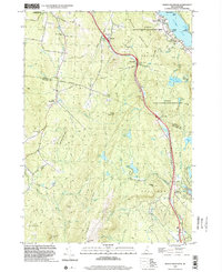
 1996 Enfield2001 Print · USGSGrafton County during the mid-1990s shows a landscape defined by the rise of Moose Mountain and the sprawling waters of Mascoma Lake. Researchers can trace the heritage of Enfield near the Shaker Bridge or follow the Appalachian Trail through the high woods of the White Mountain National Forest.
 - 1998 Map of North Grantham, 2002 Print
 1998 North Grantham2002 Print · USGSSullivan and Grafton Counties in the late nineties show a landscape where historic communal settlements meet modern transportation corridors. Researchers can trace the heritage of Lower Shaker Village, locate the Gleason Cem, or explore the wooded heights of Methodist Hill.
 - 1998 Map of Enfield Center, 2002 Print
 1998 Enfield Center2002 Print · USGSGrafton County's hill country near the Sullivan County line is captured here in the late nineties, showing a landscape of forest reserves and glacial lakes. Genealogists and locals can trace family landmarks and rural crossroads like Washburn Corner, Crystal Lake Dam Lockehaven, and Banks Pinnacle.
End of results
Showing maps 1-4 of 4
Top cities near Enfield
- Lebanon historical maps
- Claremont historical maps
- Hanover historical maps
- Hartford historical maps
- Newport historical maps
- New London historical maps
See more
Top neighborhoods of Enfield
- Enfield Center historical maps
- Lockehaven historical maps
- Montcalm historical maps
- Lower Shaker Village historical maps
- Upper Shaker Village historical maps
- Enfield Shaker Historic District historical maps
Frequently asked questions
- What are the different types of historical maps available for Enfield?
- What is the oldest map of Enfield?
- Where can I purchase historical maps of Enfield for my home or office?
- Where can I download high-res historical maps of Enfield?
- Are there historical topographic maps available for Enfield?
- Is there historical aerial imagery available for Enfield?
- Where are historical maps of Enfield sourced from?