1940s Maps of Goffstown, New Hampshire
Explore 6 historic maps of Goffstown from the 1940s. These maps offer a rare glimpse into what life looked like during the 1940s — showing old roads, neighborhoods, homes, and landmarks that have changed or disappeared over time.
Whether you're researching your family's past, planning a metal detecting trip, or studying how Goffstown's landscape evolved across the 1940s, these high-resolution maps are a powerful tool for exploring the history of this region.
- Focus on a specific era: All maps on this page are from the 1940s, giving you a focused view of this time period.
- See what’s changed: Compare century-old streets, trails, and buildings to today's modern landscape using overlays and satellite layers.
- Research with precision: Use these maps for genealogy, historical research, land use analysis, or educational projects.
- View, download, or print: Maps are fully viewable online in high resolution, and can be downloaded or printed for your own records.
Start exploring Goffstown's history through authentic maps from the 1940s. This is your window into the past.
Goffstown, NH maps
(6)- 1941 Map of Manchester
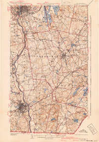 1941 Manchester1941 Print · USGSSouthern New Hampshire is captured here just before the mid-century boom, showing the river-and-rail corridor between Manchester and Nashua. Researchers can trace old ferry sites like Thorntons Ferry and find vanished rural landmarks like Londonderry Lithia Spring or the Musquash School.3 unique versions available
 - 1943 Map of Lowell
 1943 Lowell1943 Print · USGSCentral New England industrial hubs and rural borderlands are mapped here during the early 1940s. Genealogists can trace family names across Mt Misery, Barrett Hill, and small settlements like Collinsville or North Pelham.
 - 1943 Map of Fitchburg
 1943 Fitchburg1943 Print · USGSSouthern New Hampshire and northern Massachusetts are captured during the war years, showing a landscape of river-powered mill towns and mountain trails. You can trace family roots in Peterboro, locate the historic Groton School, or study the rail lines of the Boston & Maine RR.
 - 1948 Map of Boston
 1948 Boston1948 Print · USGSEastern Massachusetts and southern New Hampshire appear at an industrial peak in the late 1940s, just as suburban growth began to accelerate. Genealogists and historians can trace rail lines like the Boston and Albany RR or locate coastal landmarks like Graves Lighthouse and Fort Devens.2 unique versions available
 - 1949 Map of Portland
 1949 Portland1949 Print · USGSCoastal Maine and the New Hampshire interior are shown in detail during the late forties, from the bustling harbors to the lakeside villages. Researchers can trace historical rail networks like the Boston & Maine RR and locate coastal defenses such as Fort Preble.3 unique versions available
 - 1949 Map of Concord, 1954 Print
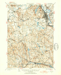 1949 Concord1954 Print · USGSMerrimack County at the close of the 1940s shows a capital city and its surrounding hill towns in transition. Genealogists and local historians can pinpoint family-named landmarks like Putney Hill, rural schoolhouses such as Waite School, and the quiet Quaker Church.4 unique versions available
End of results
Showing maps 1-6 of 6
Top cities near Goffstown
- Manchester historical maps
- Nashua historical maps
- Concord historical maps
- Derry historical maps
- Merrimack historical maps
- Londonderry historical maps
See more
Top neighborhoods of Goffstown
- Parker historical maps
- Mountain Base historical maps
- Browns Corner historical maps
- Pinardville historical maps
- Grasmere historical maps
Frequently asked questions
- What are the different types of historical maps available for Goffstown?
- What is the oldest map of Goffstown?
- Where can I purchase historical maps of Goffstown for my home or office?
- Where can I download high-res historical maps of Goffstown?
- Are there historical topographic maps available for Goffstown?
- Is there historical aerial imagery available for Goffstown?
- Where are historical maps of Goffstown sourced from?