1940s Maps of Hancock, New Hampshire
Explore 7 historic maps of Hancock from the 1940s. These maps offer a rare glimpse into what life looked like during the 1940s — showing old roads, neighborhoods, homes, and landmarks that have changed or disappeared over time.
Whether you're researching your family's past, planning a metal detecting trip, or studying how Hancock's landscape evolved across the 1940s, these high-resolution maps are a powerful tool for exploring the history of this region.
- Focus on a specific era: All maps on this page are from the 1940s, giving you a focused view of this time period.
- See what’s changed: Compare century-old streets, trails, and buildings to today's modern landscape using overlays and satellite layers.
- Research with precision: Use these maps for genealogy, historical research, land use analysis, or educational projects.
- View, download, or print: Maps are fully viewable online in high resolution, and can be downloaded or printed for your own records.
Start exploring Hancock's history through authentic maps from the 1940s. This is your window into the past.
Hancock, NH maps
(7)- 1942 Map of Keene
 1942 Keene1942 Print · USGSCheshire County at the start of the war shows a landscape of busy river valleys and upland farms. You can trace the path of the Boston & Maine RR through towns like Westmoreland and find old district landmarks like Sch No 10 or the Rand Cem.
 - 1942 Map of Lovewell Mountain
 1942 Lovewell Mountain1942 Print · USGSSullivan and Cheshire Counties are shown in detail during the early 1940s, capturing the high-country pond and mill culture of the New Hampshire hills. Researchers can trace family roots through upland landmarks like Advent Ch, School No 5, and the old Meetinghouse.4 unique versions available
 - 1943 Map of Fitchburg
 1943 Fitchburg1943 Print · USGSSouthern New Hampshire and northern Massachusetts are captured during the war years, showing a landscape of river-powered mill towns and mountain trails. You can trace family roots in Peterboro, locate the historic Groton School, or study the rail lines of the Boston & Maine RR.
 - 1948 Map of Boston
 1948 Boston1948 Print · USGSEastern Massachusetts and southern New Hampshire appear at an industrial peak in the late 1940s, just as suburban growth began to accelerate. Genealogists and historians can trace rail lines like the Boston and Albany RR or locate coastal landmarks like Graves Lighthouse and Fort Devens.2 unique versions available
 - 1948 Map of Albany, 1951 Print
 1948 Albany1951 Print · USGSThe Hudson and Connecticut River valleys are captured here in the late 1940s, showing the vital rail and water corridors of the Northeast. You can trace the Boston and Maine tracks past Mt Greylock or locate early settlements like Great Barrington and Bennington.
 - 1949 Map of Portland
 1949 Portland1949 Print · USGSCoastal Maine and the New Hampshire interior are shown in detail during the late forties, from the bustling harbors to the lakeside villages. Researchers can trace historical rail networks like the Boston & Maine RR and locate coastal defenses such as Fort Preble.3 unique versions available
 - 1949 Map of Monadnock
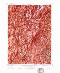 1949 Monadnock1949 Print · USGSCheshire County at the end of the 1940s is defined by the high peak of Monadnock Mtn and its many hiking paths. Genealogists and hikers can trace old rail lines like the Boston and Maine and find local landmarks such as Roxbury Sch and Hallway House.10 unique versions available
End of results
Showing maps 1-7 of 7
Top cities near Hancock
- Keene historical maps
- Weare historical maps
- Rindge historical maps
- Peterborough historical maps
- Hopkinton historical maps
- New Ipswich historical maps
See more
Top neighborhoods of Hancock
Frequently asked questions
- What are the different types of historical maps available for Hancock?
- What is the oldest map of Hancock?
- Where can I purchase historical maps of Hancock for my home or office?
- Where can I download high-res historical maps of Hancock?
- Are there historical topographic maps available for Hancock?
- Is there historical aerial imagery available for Hancock?
- Where are historical maps of Hancock sourced from?