1980s Maps of Hillsborough, New Hampshire
Explore 9 historic maps of Hillsborough from the 1980s. These maps offer a rare glimpse into what life looked like during the 1980s — showing old roads, neighborhoods, homes, and landmarks that have changed or disappeared over time.
Whether you're researching your family's past, planning a metal detecting trip, or studying how Hillsborough's landscape evolved across the 1980s, these high-resolution maps are a powerful tool for exploring the history of this region.
- Focus on a specific era: All maps on this page are from the 1980s, giving you a focused view of this time period.
- See what’s changed: Compare century-old streets, trails, and buildings to today's modern landscape using overlays and satellite layers.
- Research with precision: Use these maps for genealogy, historical research, land use analysis, or educational projects.
- View, download, or print: Maps are fully viewable online in high resolution, and can be downloaded or printed for your own records.
Start exploring Hillsborough's history through authentic maps from the 1980s. This is your window into the past.
Hillsborough, NH maps
(9)- 1984 Map of Stoddard
 1984 Stoddard1984 Print · USGSCheshire County’s high country is captured here during the 1980s, showing a landscape defined by forest reserves and quiet lakeside hamlets. You can trace the historic Monadnock-Sunapee Trail past Stoddard Rocks or locate old family landmarks like the Joslin Cem.
 - 1984 Map of Lovewell Mountain
 1984 Lovewell Mountain1984 Print · USGSSullivan County upland life in the mid-1980s is defined by its deep woods and glacial waters at the junction of three counties. Trace the historic streetscape of Washington, find old mill sites like Gee Mill, or explore the protected lands of Pillsbury State Park.3 unique versions available
 - 1985 Map of Claremont, 1986 Print
 1985 Claremont1986 Print · USGSUpper Valley and Green Mountain life are captured here in the mid-eighties, centered on the river-linked hubs of Claremont and Springfield. Trace old family routes and rail lines like the Boston & Maine RR, or locate properties near Lake Sunapee and Mount Ascutney State Park.2 unique versions available
 - 1986 Map of Concord
 1986 Concord1986 Print · USGSCentral New Hampshire in the mid-eighties shows a landscape of river-valley cities and rural villages connected by the growing interstate system. Genealogists and historians can trace old community centers like Gilmanton Ironworks or follow the Boston and Maine Railroad through Concord and Tilton.
 - 1987 Map of Deering
 1987 Deering1987 Print · USGSHillsborough County in the late 1980s reveals a landscape of high granite hills and expansive reservoirs. Genealogists and researchers can trace local landmarks from Chase Village and Slab City to family-named peaks like Goodale Hill and Peacock Hill.
 - 1987 Map of Hillsboro
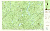
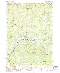
 1987 Hillsboro1987 Print · USGSHillsborough County in the late eighties reveals a landscape of river-valley villages and ancestral homesteads. Trace the layout of historic settlements like Clinton Village and Antrim or locate the landmark Franklin Pierce Homestead.
 - 1987 Map of Henniker
 1987 Henniker1987 Print · USGSHenniker and the winding Contoocook River are captured here in the late 1980s as the town maintained its classic New Hampshire character. Researchers can trace local landmarks from Henniker Junction to the quiet corner of Colby, or locate family sites near Keyser Pond.2 unique versions available
 - 1987 Map of Hillsboro Upper Village
 1987 Hillsboro Upper Village1987 Print · USGSHillsborough and Bradford are captured here in the late eighties, showing a landscape defined by historic village centers and conservation lands. Researchers can trace the layout of Hillsboro Upper Village, locate several Cem sites, and explore the terrain around Lake Massasecum and Fox State Forest.
 - 1988 Map of Concord
 1988 Concord1988 Print · USGSCentral New Hampshire in the late eighties centers on the industrial and political hub of Concord. Researchers can trace the Boston and Maine RR along the Merrimack River or locate recreation landmarks like Bear Brook State Park and Massabesic Lake.
End of results
Showing maps 1-9 of 9
Top cities near Hillsborough
- Weare historical maps
- Peterborough historical maps
- Hopkinton historical maps
- New Boston historical maps
- Newport historical maps
- Sunapee historical maps
See more
Top neighborhoods of Hillsborough
- Hillsboro Upper Village historical maps
- Hillsboro Center historical maps
- Hillsboro Lower Village historical maps
- Hillsboro historical maps
Frequently asked questions
- What are the different types of historical maps available for Hillsborough?
- What is the oldest map of Hillsborough?
- Where can I purchase historical maps of Hillsborough for my home or office?
- Where can I download high-res historical maps of Hillsborough?
- Are there historical topographic maps available for Hillsborough?
- Is there historical aerial imagery available for Hillsborough?
- Where are historical maps of Hillsborough sourced from?