1960s Maps of Potash Corner, Hudson
Explore 2 historic maps of Potash Corner from the 1960s. These maps offer a rare glimpse into what life looked like during the 1960s — showing old roads, neighborhoods, homes, and landmarks that have changed or disappeared over time.
Whether you're researching your family's past, planning a metal detecting trip, or studying how Potash Corner's landscape evolved across the 1960s, these high-resolution maps are a powerful tool for exploring the history of this region.
- Focus on a specific era: All maps on this page are from the 1960s, giving you a focused view of this time period.
- See what’s changed: Compare century-old streets, trails, and buildings to today's modern landscape using overlays and satellite layers.
- Research with precision: Use these maps for genealogy, historical research, land use analysis, or educational projects.
- View, download, or print: Maps are fully viewable online in high resolution, and can be downloaded or printed for your own records.
Start exploring Potash Corner's history through authentic maps from the 1960s. This is your window into the past.
Potash Corner, Hudson maps
(2)- 1961 Map of Boston
 1961 Boston1961 Print · USGSThe Massachusetts coastline and its industrial interior are detailed here in the mid-twentieth century, from the Monadnock highlands to Cape Cod. Researchers can trace the rail routes of the Boston and Maine or locate landmarks like Fort Devens and the Wachusett Reservoir.2 unique versions available
 - 1968 Map of Nashua North, 1971 Print
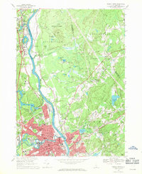 1968 Nashua North1971 Print · USGSNashua and Hudson appear in a state of mid-century transformation as the suburbs expanded along the Merrimack River in the late sixties. Genealogists can locate several burial grounds like Edgewood Cem and Boyd Cem or trace the path of the Boston and Maine railroad.3 unique versions available
End of results
Showing maps 1-2 of 2
Top cities near Potash Corner
- Manchester historical maps
- Lowell historical maps
- Nashua historical maps
- Lawrence historical maps
- Methuen historical maps
- Billerica historical maps
See more
Frequently asked questions
- What are the different types of historical maps available for Potash Corner?
- What is the oldest map of Potash Corner?
- Where can I purchase historical maps of Potash Corner for my home or office?
- Where can I download high-res historical maps of Potash Corner?
- Are there historical topographic maps available for Potash Corner?
- Is there historical aerial imagery available for Potash Corner?
- Where are historical maps of Potash Corner sourced from?