Old Maps of Windsor, New Hampshire for Metal Detecting
Plan your next treasure hunt with 26 historic maps of Windsor. Find old homesites, ghost towns, trails, and gathering spots that may be lost to time — perfect for identifying promising metal detecting locations.
- Locate forgotten sites: Uncover places like long-lost settlements, abandoned rail lines, or gathering spots.
- Plan better hunts: Use map overlays combined with LiDAR or satellite views to narrow in on historically rich areas.
- Made for detectorists: Thousands of hobbyists use these maps to discover relics, coins, and hidden history.
Use these historic maps to boost your research and find new opportunities beneath the surface of Windsor.
Windsor, NH maps
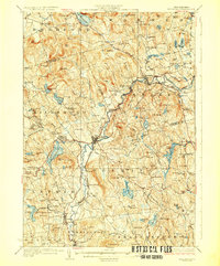
(26)- 1926 Map of Hillsboro
 1926 Hillsboro1926 Print · USGSHillsborough County's mill towns and hill farms are captured here in the mid-1920s as the rail-and-river economy remained the local heartbeat. Researchers can trace the Boston and Maine line through Slab City or locate the Birthplace of Franklin Pierce near Jackman Reservoir.2 unique versions available
 - 1929 Map of Hillsboro
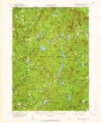
 1929 Hillsboro1929 Print · USGSCentral New Hampshire in the late twenties reveals a landscape of river-powered towns and remote hill farms. Trace family history at the Birthplace of Franklin Pierce or locate old schoolhouses like Liberty Union Sch and Hemlock Sch.5 unique versions available
 - 1930 Map of Lovewell Mountain
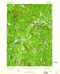
 1930 Lovewell Mountain1930 Print · USGSThe Cheshire and Sullivan County borderlands come alive in this late 1920s survey of the New Hampshire highlands. Researchers can locate long-standing crossroads like East Lempster, find vanished rural education at Fifield Sch, or trace the old Loverens Mill site.4 unique versions available
 - 1942 Map of Lovewell Mountain
 1942 Lovewell Mountain1942 Print · USGSSullivan and Cheshire Counties are shown in detail during the early 1940s, capturing the high-country pond and mill culture of the New Hampshire hills. Researchers can trace family roots through upland landmarks like Advent Ch, School No 5, and the old Meetinghouse.4 unique versions available
 - 1949 Map of Portland
 1949 Portland1949 Print · USGSCoastal Maine and the New Hampshire interior are shown in detail during the late forties, from the bustling harbors to the lakeside villages. Researchers can trace historical rail networks like the Boston & Maine RR and locate coastal defenses such as Fort Preble.3 unique versions available
 - 1950 Map of Glens Falls
 1950 Glens Falls1950 Print · USGSThe Adirondacks and the Green Mountains meet in this mid-century survey of the New York and Vermont borderlands. Researchers can trace the industrial rail corridors of the Rutland RR and Delaware & Hudson RR connecting Glens Falls, Rutland, and the shores of Lake George.
 - 1956 Map of Portland, 1963 Print
 1956 Portland1963 Print · USGSSouthern Maine and eastern New Hampshire are captured here in the mid-fifties, during a time of major highway expansion and military growth. You can trace the path of the Maine Turnpike and locate landmarks like the Portsmouth Naval Shipyard and Sebago Lake.4 unique versions available
 - 1956 Map of Glens Falls, 1968 Print
 1956 Glens Falls1968 Print · USGSUpper New York and the Vermont mountains are captured here in the mid-fifties, showing the rugged rail-and-river network of the Northeast. Researchers can trace the paths of the Delaware and Hudson RR and Rutland RR as they wind through valley towns like Poultney and Whitehall.3 unique versions available
 - 1957 Map of Lovewell Mountain, 1959 Print
 1957 Lovewell Mountain1959 Print · USGSThe hill country of southwestern New Hampshire is captured here in the mid-1950s, showing the intersection of Sullivan, Cheshire, and Hillsborough counties. Researchers can trace old routes like the Dartmouth College Highway and locate rural landmarks such as Advent Ch, Mill Village, and East Lempster.4 unique versions available
 - 1957 Map of Hillsboro, 1960 Print
 1957 Hillsboro1960 Print · USGSHillsborough County in the mid-fifties remains a landscape of river-powered mill towns and mountain forests. Researchers can trace the Boston and Maine rail corridor through Henniker and Hillsboro, or locate family sites near Donkey School and Maple Avenue Cemetery.3 unique versions available
 - 1959 Map of Glens Falls
 1959 Glens Falls1959 Print · USGSUpper New York and Vermont are captured here during the late 1950s, a period of transition for these mountain communities. Researchers can trace the legacy of the region's river-and-rail economy through landmarks like Lake George, Saratoga Springs, and Killington Peak.2 unique versions available
 - 1959 Map of Portland
 1959 Portland1959 Print · USGSThe Maine and New Hampshire coastlines meet in this mid-century portrait of maritime commerce and inland rail networks. Researchers can trace the legacy of coastal defense at Fort Williams and follow the historic path of the Maine Central RR through the White Mountain National Forest.2 unique versions available
 - 1963 Map of Portland
 1963 Portland1963 Print · USGSCoastal Maine and New Hampshire thrived as maritime and industrial hubs during the mid-sixties, linked by a dense network of rail and river. Researchers can trace historic transit corridors like the Maine Central RR and locate key sites such as the Portsmouth Naval Shipyard or Pease Air Force Base.3 unique versions available
 - 1964 Map of Glens Falls
 1964 Glens Falls1964 Print · USGSThe tri-state borderlands of New York, Vermont, and New Hampshire appear here in the mid-1960s. Researchers can trace the rail routes of the Rutland RR and find historic sites like Ticonderoga and Saratoga National Historical Park.
 - 1984 Map of Stoddard
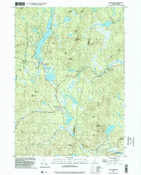
 1984 Stoddard1984 Print · USGSCheshire County’s high country is captured here during the 1980s, showing a landscape defined by forest reserves and quiet lakeside hamlets. You can trace the historic Monadnock-Sunapee Trail past Stoddard Rocks or locate old family landmarks like the Joslin Cem.
 - 1984 Map of Lovewell Mountain
 1984 Lovewell Mountain1984 Print · USGSSullivan County upland life in the mid-1980s is defined by its deep woods and glacial waters at the junction of three counties. Trace the historic streetscape of Washington, find old mill sites like Gee Mill, or explore the protected lands of Pillsbury State Park.3 unique versions available
 - 1985 Map of Claremont, 1986 Print
 1985 Claremont1986 Print · USGSUpper Valley and Green Mountain life are captured here in the mid-eighties, centered on the river-linked hubs of Claremont and Springfield. Trace old family routes and rail lines like the Boston & Maine RR, or locate properties near Lake Sunapee and Mount Ascutney State Park.2 unique versions available
 - 1986 Map of Concord
 1986 Concord1986 Print · USGSCentral New Hampshire in the mid-eighties shows a landscape of river-valley cities and rural villages connected by the growing interstate system. Genealogists and historians can trace old community centers like Gilmanton Ironworks or follow the Boston and Maine Railroad through Concord and Tilton.
 - 1987 Map of Hillsboro
 1987 Hillsboro1987 Print · USGSHillsborough County in the late eighties reveals a landscape of river-valley villages and ancestral homesteads. Trace the layout of historic settlements like Clinton Village and Antrim or locate the landmark Franklin Pierce Homestead.
 - 1988 Map of Concord
 1988 Concord1988 Print · USGSCentral New Hampshire in the late eighties centers on the industrial and political hub of Concord. Researchers can trace the Boston and Maine RR along the Merrimack River or locate recreation landmarks like Bear Brook State Park and Massabesic Lake.
 - 1995 Map of Hillsboro, 1999 Print
 1995 Hillsboro1999 Print · USGSHillsborough County in the mid-nineties reveals a landscape of enduring village centers and significant state conservation lands. Genealogists and historians can trace family locations near the Franklin Pierce Homestead or explore the shores of Gregg Lake and the Contoocook River.
 - 1998 Map of Washington, 2002 Print
 1998 Washington2002 Print · USGSSullivan County at the close of the twentieth century remains a landscape of deep woods and interconnected glacial ponds. Genealogists and hikers can trace the village layout of Washington or locate historic landmarks like Bradford Spring and the Center Sch.
 - 1998 Map of Stoddard, 2002 Print
 1998 Stoddard2002 Print · USGSNew Hampshire's high country near the turn of the millennium shows a landscape shaped by glacial ponds and granite peaks. Genealogists and hikers can trace the Monadnock-Sunapee Trail through old settlements like Mill Village and Loverens Mill.
 - 2024 Map of Hillsboro, 2024 Print
 2024 Hillsboro2024 Print · USGSHillsborough County in the 2020s remains a landscape of river-valley villages and numerous hill-country cemeteries. Researchers can trace family sites from Pine Hill Cem to Maplewood Cem while following the path of the Hillsborough Rec Rail Trail.
 - 2024 Map of Stoddard, 2024 Print
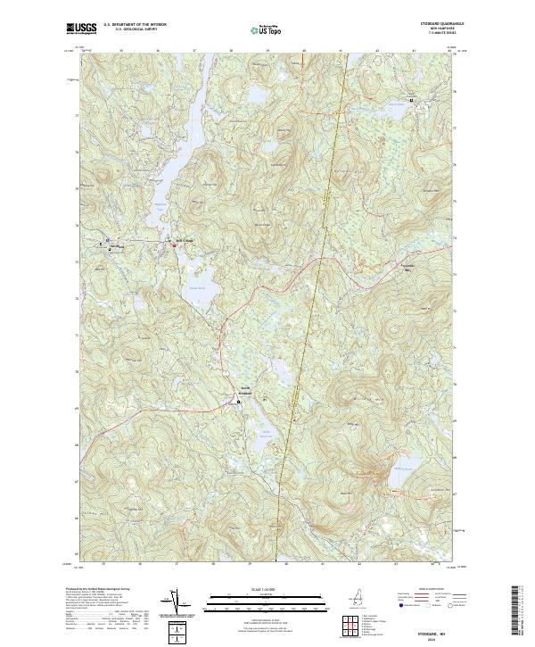 2024 Stoddard2024 Print · USGSThe upland terrain of Cheshire County is documented here in the early twenty-first century, showing a region defined by its water-powered past and high ridges. Researchers can locate family burial sites at Dow Hill Cem and Robb Cem or trace old mill sites near Loverens Mill.
Showing maps 1-25 of 26
Top cities near Windsor
- Keene historical maps
- Weare historical maps
- Swanzey historical maps
- Peterborough historical maps
- Newport historical maps
- Sunapee historical maps
See more
Frequently asked questions
- What are the different types of historical maps available for Windsor?
- What is the oldest map of Windsor?
- Where can I purchase historical maps of Windsor for my home or office?
- Where can I download high-res historical maps of Windsor?
- Are there historical topographic maps available for Windsor?
- Is there historical aerial imagery available for Windsor?
- Where are historical maps of Windsor sourced from?