Old Maps of Millville, New Jersey
Explore 26 old maps of Millville, spanning from 1890 to today. These high-resolution historic maps reveal how streets, neighborhoods, landmarks, and natural features evolved over time — perfect for genealogy, metal detecting, research, and local history exploration.
What you can do with these maps:
- See how Millville changed over time: Compare historical maps to modern-day views to trace roads, homesites, rail lines & more.
- View detailed metadata: Each map includes creators, publishers, year, scale, and archive source.
- Overlay maps with satellite & LiDAR: Visualize the past alongside modern tools to explore terrain & human change.
- Trusted historical sources: Maps sourced from the USGS, Library of Congress, and other archives.
- Access maps your way: View online, download high-res files, or order prints for personal or research use.
Start exploring old maps of Millville to uncover forgotten places, hidden landmarks, and the deep history beneath your feet.
Millville, NJ maps
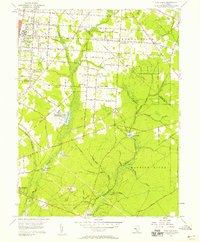
(26)- 1890 Map of Tuckahoe
 1890 Tuckahoe1890 Print · USGSCovers Millville, including Vineland, Hamilton Township, and other nearby areas
 - 1890 Map of Bridgeton
 1890 Bridgeton1890 Print · USGSCovers Millville, including Vineland, Bridgeton, and other nearby areas
 - 1893 Map of Tuckahoe
 1893 Tuckahoe1893 Print · USGSCovers Millville, including Vineland, Hamilton Township, and other nearby areas4 unique versions available
 - 1894 Map of Bridgeton
 1894 Bridgeton1894 Print · USGSCovers Millville, including Vineland, Bridgeton, and other nearby areas4 unique versions available
 - 1899 Map of Vineland
 1899 Vineland1899 Print · USGSCovers Millville, including Vineland, Dover, and other nearby areas3 unique versions available
 - 1918 Map of Tuckahoe, 1921 Print
 1918 Tuckahoe1921 Print · USGSCovers Millville, including Vineland, Hamilton Township, and other nearby areas
 - 1919 Map of Vineland, 1921 Print
 1919 Vineland1921 Print · USGSCovers Millville, including Vineland, Dover, and other nearby areas
 - 1941 Map of Tuckahoe
 1941 Tuckahoe1941 Print · USGSCovers Millville, including Vineland, Hamilton Township, and other nearby areas
 - 1942 Map of Bridgeton
 1942 Bridgeton1942 Print · USGSCovers Millville, including Vineland, Bridgeton, and other nearby areas
 - 1946 Map of Wilmington, 1948 Print
 1946 Wilmington1948 Print · USGSCovers Millville, including Philadelphia, Toms River, and other nearby areas2 unique versions available
 - 1948 Map of Bridgeton
 1948 Bridgeton1948 Print · USGSCovers Millville, including Vineland, Bridgeton, and other nearby areas3 unique versions available
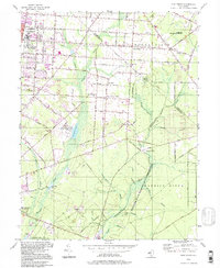
 - 1953 Map of Millville, 1955 Print
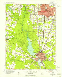 1953 Millville1955 Print · USGSCovers Millville, including Vineland, Lawrence Township, and other nearby areas4 unique versions available
 - 1953 Map of Bridgeton, 1955 Print
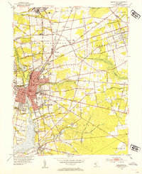 1953 Bridgeton1955 Print · USGSCovers Millville, including Bridgeton, Fairfield Township, and other nearby areas4 unique versions available
 - 1955 Map of Wilmington
 1955 Wilmington1955 Print · USGSCovers Millville, including Philadelphia, Toms River, and other nearby areas
 - 1956 Map of Dividing Creek, 1957 Print
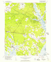 1956 Dividing Creek1957 Print · USGSCovers Millville, including Maurice River Township, Commercial Township, and other nearby areas6 unique versions available
 - 1956 Map of Port Elizabeth, 1957 Print
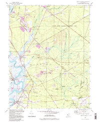
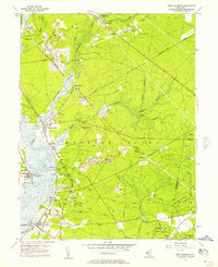 1956 Port Elizabeth1957 Print · USGSCovers Millville, including Upper Township, Maurice River Township, and other nearby areas4 unique versions available
 - 1956 Map of Five Points, 1958 Print
 1956 Five Points1958 Print · USGSCovers Millville, including Vineland, Maurice River Township, and other nearby areas3 unique versions available
 - 1957 Map of Wilmington
 1957 Wilmington1957 Print · USGSCovers Millville, including Philadelphia, Toms River, and other nearby areas2 unique versions available
 - 1959 Map of Wilmington
 1959 Wilmington1959 Print · USGSCovers Millville, including Philadelphia, Toms River, and other nearby areas3 unique versions available
 - 1966 Map of Wilmington, 1968 Print
 1966 Wilmington1968 Print · USGSCovers Millville, including Philadelphia, Toms River, and other nearby areas4 unique versions available
 - 1972 Map of Wilmington, 1976 Print
 1972 Wilmington1976 Print · USGSCovers Millville, including Philadelphia, Toms River, and other nearby areas2 unique versions available
 - 1984 Map of Atlantic City, 1985 Print
 1984 Atlantic City1985 Print · USGSCovers Millville, including Vineland, Egg Harbor Township, and other nearby areas
 - 1984 Map of Dover, 1985 Print
 1984 Dover1985 Print · USGSCovers Millville, including Vineland, Dover, and other nearby areas
 - 1994 Map of Five Points, 1998 Print
 1994 Five Points1998 Print · USGSCovers Millville, including Vineland, Maurice River Township, and other nearby areas
 - 1994 Map of Port Elizabeth, 1998 Print
 1994 Port Elizabeth1998 Print · USGSCovers Millville, including Upper Township, Maurice River Township, and other nearby areas
Showing maps 1-25 of 26
Top cities near Millville
- Vineland historical maps
- Winslow Township historical maps
- Monroe Township historical maps
- Hammonton historical maps
- Hamilton Township historical maps
- Bridgeton historical maps
See more
Top neighborhoods of Millville
- Clarks Mill historical maps
- Farmingdale historical maps
- Menantico historical maps
- Laurel Lake historical maps
- Roosevelt Park historical maps
Frequently asked questions
- What are the different types of historical maps available for Millville?
- What is the oldest map of Millville?
- Where can I purchase historical maps of Millville for my home or office?
- Where can I download high-res historical maps of Millville?
- Are there historical topographic maps available for Millville?
- Is there historical aerial imagery available for Millville?
- Where are historical maps of Millville sourced from?