1950s Maps of Millville, New Jersey
Explore 8 historic maps of Millville from the 1950s. These maps offer a rare glimpse into what life looked like during the 1950s — showing old roads, neighborhoods, homes, and landmarks that have changed or disappeared over time.
Whether you're researching your family's past, planning a metal detecting trip, or studying how Millville's landscape evolved across the 1950s, these high-resolution maps are a powerful tool for exploring the history of this region.
- Focus on a specific era: All maps on this page are from the 1950s, giving you a focused view of this time period.
- See what’s changed: Compare century-old streets, trails, and buildings to today's modern landscape using overlays and satellite layers.
- Research with precision: Use these maps for genealogy, historical research, land use analysis, or educational projects.
- View, download, or print: Maps are fully viewable online in high resolution, and can be downloaded or printed for your own records.
Start exploring Millville's history through authentic maps from the 1950s. This is your window into the past.
Millville, NJ maps
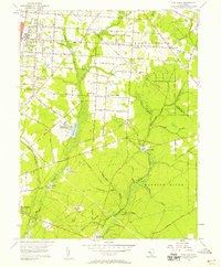
(8)- 1953 Map of Millville, 1955 Print
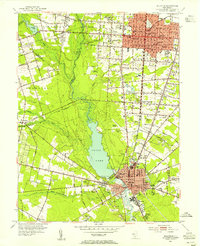 1953 Millville1955 Print · USGSCumberland County thrived in the early fifties as a hub of rail transport and agriculture centered around the Maurice River. Genealogists and historians can trace family locations through numerous sites like Siloam Cem, Carmel, and the Sacred Heart Ch.4 unique versions available
 - 1953 Map of Bridgeton, 1955 Print
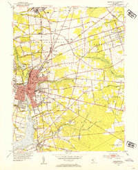 1953 Bridgeton1955 Print · USGSBridgeton and its surrounding farm colonies are captured in the early 1950s as the Cumberland County landscape balanced heavy industry with major agricultural production. Genealogists can trace family names and sites through numerous rural landmarks, including Friendship Church, the Old Presbyterian Cemetery, and the historic settlement of Gouldtown.4 unique versions available
 - 1955 Map of Wilmington
 1955 Wilmington1955 Print · USGSThe Delaware Valley and Jersey Shore are seen here during the mid-fifties era of rapid suburban expansion and highway development. You can trace the path of the New Jersey Turnpike, locate the Fort Dix Military Reservation, or explore the rail networks of the Pennsylvania Railroad.
 - 1956 Map of Dividing Creek, 1957 Print
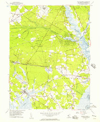 1956 Dividing Creek1957 Print · USGSCumberland County's wetlands and river towns are caught in detail during the mid-fifties, showing the transition from traditional river life to industrial growth. Trace family roots and old rail lines through Dividing Creek, Mauricetown, and the Old Bowkers Railroad Grade.6 unique versions available
 - 1956 Map of Port Elizabeth, 1957 Print
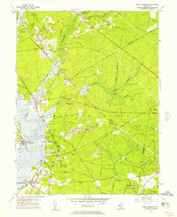 1956 Port Elizabeth1957 Print · USGSCoastal Cumberland County villages thrive along the river during the mid-fifties, supported by a mix of maritime trade and rail transport. Genealogists can trace family names at Leesburg Sch or locate historic industry at Fries Mill and Mauricetown Sta.4 unique versions available
 - 1956 Map of Five Points, 1958 Print
 1956 Five Points1958 Print · USGSCumberland County communities appear in the mid-fifties during a period of agricultural and institutional growth. Genealogists and local historians can trace the foundations of the Manantico Colony, locate St Marys Ch, or find the mill sites at Leamings Mill.3 unique versions available
 - 1957 Map of Wilmington
 1957 Wilmington1957 Print · USGSThe mid-Atlantic coastal plain comes alive in the mid-fifties as the New Jersey Turnpike and Garden State Parkway redefine travel. Researchers can trace the rail-to-road transition and find landmarks like Ship John Shoal Light and the Fort Dix Military Reservation.2 unique versions available
 - 1959 Map of Wilmington
 1959 Wilmington1959 Print · USGSThe Delaware Valley and Jersey Shore are seen here in the late fifties, during a period of massive suburban and highway expansion. Researchers can trace mid-century infrastructure like the N J Turnpike or locate coastal landmarks from Barnegat Bay to the Maurice River.3 unique versions available
End of results
Showing maps 1-8 of 8
Top cities near Millville
- Vineland historical maps
- Winslow Township historical maps
- Monroe Township historical maps
- Hammonton historical maps
- Hamilton Township historical maps
- Bridgeton historical maps
See more
Top neighborhoods of Millville
- Clarks Mill historical maps
- Farmingdale historical maps
- Menantico historical maps
- Laurel Lake historical maps
- Roosevelt Park historical maps
Frequently asked questions
- What are the different types of historical maps available for Millville?
- What is the oldest map of Millville?
- Where can I purchase historical maps of Millville for my home or office?
- Where can I download high-res historical maps of Millville?
- Are there historical topographic maps available for Millville?
- Is there historical aerial imagery available for Millville?
- Where are historical maps of Millville sourced from?