1960s Maps of Pitman, New Jersey
Explore 3 historic maps of Pitman from the 1960s. These maps offer a rare glimpse into what life looked like during the 1960s — showing old roads, neighborhoods, homes, and landmarks that have changed or disappeared over time.
Whether you're researching your family's past, planning a metal detecting trip, or studying how Pitman's landscape evolved across the 1960s, these high-resolution maps are a powerful tool for exploring the history of this region.
- Focus on a specific era: All maps on this page are from the 1960s, giving you a focused view of this time period.
- See what’s changed: Compare century-old streets, trails, and buildings to today's modern landscape using overlays and satellite layers.
- Research with precision: Use these maps for genealogy, historical research, land use analysis, or educational projects.
- View, download, or print: Maps are fully viewable online in high resolution, and can be downloaded or printed for your own records.
Start exploring Pitman's history through authentic maps from the 1960s. This is your window into the past.
Pitman, NJ maps
(3)- 1966 Map of Pitman East, 1968 Print
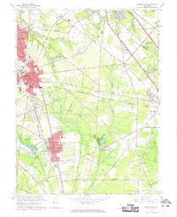 1966 Pitman East1968 Print · USGSMid-century Gloucester County comes into focus as the growth of Glassboro and its college meets the rural reaches of Monroe and Franklin. Researchers can trace the Pennsylvania-Reading Seashore Lines or locate family sites like Fries Mill and Hill Crest Memorial Park.3 unique versions available
 - 1966 Map of Wilmington, 1968 Print
 1966 Wilmington1968 Print · USGSThe Delaware Valley and Jersey Shore are seen here in the mid-1960s, documenting a landscape of dense industrial cities and emerging coastal resorts. Researchers can trace the sprawling rail networks of the Pennsylvania Railroad or locate landmarks like Fort Dix Military Reservation and Elk Neck State Park.4 unique versions available
 - 1967 Map of Pitman West, 1969 Print
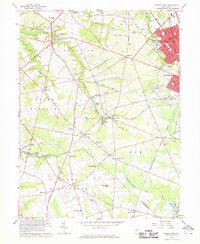 1967 Pitman West1969 Print · USGSGloucester County was a landscape of orchard-rich townships and growing rail-connected boroughs during the late sixties. Genealogists can trace family roots through historic landmarks like Wrights Mill, Siloam Ch, and the many hamlets from Mullica Hill to Monroeville.3 unique versions available
End of results
Showing maps 1-3 of 3
Top cities near Pitman
- Philadelphia historical maps
- Upper Darby historical maps
- Camden historical maps
- Cherry Hill Township historical maps
- Vineland historical maps
- Washington Township historical maps
See more
Top neighborhoods of Pitman
Frequently asked questions
- What are the different types of historical maps available for Pitman?
- What is the oldest map of Pitman?
- Where can I purchase historical maps of Pitman for my home or office?
- Where can I download high-res historical maps of Pitman?
- Are there historical topographic maps available for Pitman?
- Is there historical aerial imagery available for Pitman?
- Where are historical maps of Pitman sourced from?