Old Maps of Middletown Township, New Jersey for Genealogy
Trace your family roots with 57 historic maps of Middletown Township. These high-res maps reveal old neighborhoods, homesites, landmarks, and streets — helping you uncover where your ancestors lived and how the area evolved over time.
- Explore historic neighborhoods: Identify where your relatives may have lived in the 1800s or 1900s.
- Compare maps over time: Trace the changes in streets, buildings, and landmarks for multi-generational research.
- Perfect for genealogy & ancestry research: Used by family historians and researchers to map out lineage and migration.
These maps are an incredible resource for exploring your personal connection to Middletown Township's past.
Middletown Township, NJ maps
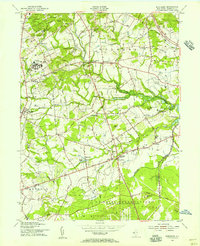
(57)- 1888 Map of Sandy Hook
 1888 Sandy Hook1888 Print · USGSThe Monmouth County coastline and interior are meticulously detailed in the late 1880s, before modern development reshaped the Jersey Shore. Genealogists and historians can trace rail lines like the New York and Long Branch Railroad through early settlements such as Middletown, Hazlet, and Holmdel.
 - 1893 Map of Sandy Hook
 1893 Sandy Hook1893 Print · USGSMonmouth County's coast and interior are intricately detailed in the late Victorian era, before the modern development of the Jersey Shore. Researchers can trace the early rail networks of the New Jersey Southern Railroad and locate historic maritime landmarks like Sandy Hook Light and Tinton Falls.2 unique versions available
 - 1901 Map of Sandy Hook
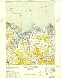
 1901 Sandy Hook1901 Print · USGSThe Jersey Shore and Raritan Bay come to life in this late Victorian-era survey of the Monmouth County coast. Trace the early rail lines at Port Monmouth Sta or locate family landmarks like Stone Church and Telegraph Hill.6 unique versions available
 - 1902 Map of Navesink
 1902 Navesink1902 Print · USGSCoastal New Jersey and the Raritan valley are shown here at the turn of the century, when industrial hubs and maritime defenses defined the shoreline. Genealogists can trace family roots through settlements like Old Bridge and Milltown, or locate local landmarks like the State Reform School.3 unique versions available
 - 1918 Map of Sandy Hook, 1921 Print
 1918 Sandy Hook1921 Print · USGSMonmouth County's coastline and interior settlements are captured during the final months of the First World War. Genealogists and historians can trace the early rail network through Little Silver Sta or locate old landmarks like Stone Church and Fort Hancock.
 - 1944 Map of Newark, 1971 Print
 1944 Newark1971 Print · USGSThe industrial corridor from Philadelphia to New York was in a period of massive transition during the mid-forties. Genealogists and researchers can trace the rail lines of the Lehigh Valley RR, locate military installations like Picatinny Arsenal, and explore the early sprawl near Levittown.5 unique versions available
 - 1947 Map of Keyport
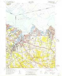
 1947 Keyport1947 Print · USGSMonmouth County's bay shore and its post-war industrial landscape are captured here just as the rail-driven economy reached its peak. Researchers can trace family roots through the Green Grove Cemetery or locate old industry at the Craigen Brick Co and Keyport Rubber Factory.
 - 1947 Map of Marlboro
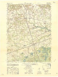
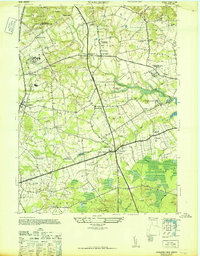 1947 Marlboro1947 Print · USGSMonmouth County's countryside appears here in the years following the war, characterized by its mix of historic farm estates and regional institutions. Researchers can trace the grounds of the Marlboro State Hospital for the Insane or locate industrial sites like the Phalanx Cannery.
 - 1947 Map of Sandy Hook, 1950 Print
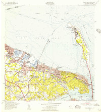
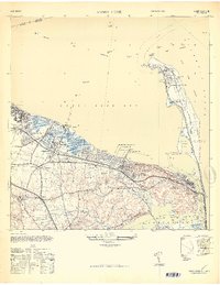 1947 Sandy Hook1950 Print · USGSMonmouth County's coastline comes alive in this late 1940s survey of the iconic barrier spit and its neighboring mainland harbor towns. Genealogists and historians can trace family properties like the Elgan Rauch Farm or find lost landmarks such as the Roseland Hotel and Belford Sta.
 - 1947 Map of Sandy Hook, 1950 Print
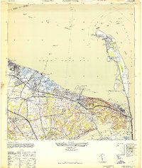 1947 Sandy Hook1950 Print · USGSThe Monmouth County coastline at the end of the 1940s shows a landscape of military defense and busy maritime piers. Genealogists can trace family landmarks like the N J Strauss Farm or locate old community centers like St Clements Ch and Harmony Cem.
 - 1949 Map of Newark
 1949 Newark1949 Print · USGSThe industrial corridor between Philadelphia and New York comes alive in this post-war survey. Genealogists and historians can trace the massive rail networks of the Reading Railroad and locate major installations like Fort Dix or Picatinny Arsenal.2 unique versions available
 - 1949 Map of New York, 1951 Print
 1949 New York1951 Print · USGSLong Island and its surrounding waters are documented here in the late 1940s, just as the postwar suburban boom began to transform the region. Genealogists and historians can trace the early layouts of Idlewild Airport, Mitchell Field, and the established routes of the Long Island RR.
 - 1954 Map of New York
 1954 New York1954 Print · USGSLong Island and the New York metropolitan area are shown during the height of post-war suburbanization. Genealogists and historians can trace the growth of Levittown, the infrastructure of the Long Island Rail Road, and landmarks like Mitchel Afb.2 unique versions available
 - 1954 Map of Marlboro, 1956 Print
 1954 Marlboro1956 Print · USGSMonmouth County in the mid-fifties is captured here as a landscape of agricultural tradition meeting modern infrastructure. Genealogists and historians can trace family locations near Colts Neck, the Marlboro State Hospital, and smaller hamlets like Bradevelt or Scobeyville.5 unique versions available
 - 1954 Map of Long Branch, 1956 Print
 1954 Long Branch1956 Print · USGSThe northern Jersey shore and its military installations come into focus in the mid-fifties as suburban growth begins to accelerate. Researchers can trace the layout of Fort Monmouth, locate Red Bank Airport, or find family names at Woodbine Cemetery and Mt Olivet Cemetery.5 unique versions available
 - 1954 Map of Keyport, 1956 Print
 1954 Keyport1956 Print · USGSMonmouth County's northern bayshore is caught in a moment of rapid postwar growth as the Garden State Parkway begins to reshape the landscape. Trace ancestral roots through detailed renderings of Keyport, Matawan, and Keansburg, or locate family sites near Rose Hill Cem and Van Marters Corner.4 unique versions available
 - 1954 Map of Sandy Hook, 1956 Print
 1954 Sandy Hook1956 Print · USGSCoastal New Jersey's bayshore and peninsula are captured here in the mid-1950s, showcasing a landscape of military reservations and harbor towns. Researchers can trace the legacy of Fort Hancock and the Sandy Hook Lighthouse or locate family roots near St Marys Sch and Harmony Cem.6 unique versions available
 - 1956 Map of Newark
 1956 Newark1956 Print · USGSThe industrial heart of the Mid-Atlantic is captured here at the dawn of the highway era, tracing the dense corridors between Newark and Philadelphia. Genealogists and local historians can map the rail networks of the Reading RR or locate mid-century military life at Fort Dix Military Reservation.2 unique versions available
 - 1957 Map of Newark
 1957 Newark1957 Print · USGSThe industrial and military heart of the Mid-Atlantic is mapped during its post-war suburban boom. Genealogists and historians can trace the intricate rail corridors of the Reading Railroad and locate key landmarks from Princeton University to Fort Hancock.
 - 1957 Map of New York, 1975 Print
 1957 New York1975 Print · USGSLong Island and the New York metropolitan area are shown in this mid-century survey during a period of massive suburban growth and industrial expansion. Researchers can trace the Long Island RR network and locate landmarks like Fort Tilden or the Brookhaven National Laboratory.
 - 1958 Map of New York
 1958 New York1958 Print · USGSLong Island at the height of its postwar expansion reveals a landscape of rapidly growing suburbs and critical military installations. Genealogists and historians can trace the early footprints of Levittown, the terminals of Idlewild Airport, and the grounds of Brookhaven National Laboratory.3 unique versions available
 - 1958 Map of Marlboro
 1958 Marlboro1958 Print · USGSMonmouth County's interior is captured here in the late fifties, showing a landscape of institutional campuses, family farms, and cider spirits. Researchers can trace local heritage through landmarks like Marlboro State Hospital for the Insane, Lairds Distillery, and the Collier Foundation School for Wayward Girls.
 - 1960 Map of Newark
 1960 Newark1960 Print · USGSThe industrial heart of the Mid-Atlantic is shown at mid-century, stretching from the dense urban centers of Newark and Philadelphia to the Blue Mountain ridges. Researchers can trace historic rail lines, coastal defenses at Fort Hancock, and the riverfront growth of Trenton and Easton.3 unique versions available
 - 1960 Map of New York, 1979 Print
 1960 New York1979 Print · USGSLong Island and the five boroughs are shown at a transformative moment mid-century as suburban expansion reshaped the landscape. Researchers can trace family roots through evolving neighborhoods from Rockville Centre to Sayville, or locate historic maritime landmarks like Eatons Neck and Montauk Point.2 unique versions available
 - 1964 Map of Newark
 1964 Newark1964 Print · USGSGreater New Jersey and eastern Pennsylvania appear at the peak of their industrial and rail-centered development in the mid-sixties. Genealogists and historians can trace the paths of the Pennsylvania RR, identify mid-century landmarks like CAMP KILMER, or follow the Schuylkill River through READING.2 unique versions available
Showing maps 1-25 of 57
Top cities near Middletown Township
- New York historical maps
- Woodbridge Township historical maps
- Old Bridge Township historical maps
- Howell Township historical maps
- Perth Amboy historical maps
- Sayreville historical maps
See more
Top neighborhoods of Middletown Township
- Leonardville historical maps
- Navesink historical maps
- North Middletown historical maps
- Belford historical maps
- Oak Hill historical maps
- Chapel Hill historical maps
See more
Frequently asked questions
- What are the different types of historical maps available for Middletown Township?
- What is the oldest map of Middletown Township?
- Where can I purchase historical maps of Middletown Township for my home or office?
- Where can I download high-res historical maps of Middletown Township?
- Are there historical topographic maps available for Middletown Township?
- Is there historical aerial imagery available for Middletown Township?
- Where are historical maps of Middletown Township sourced from?