1940s Maps of Passaic County, New Jersey
Explore 19 historic maps of Passaic County from the 1940s. These maps offer a rare glimpse into what life looked like during the 1940s — showing old roads, neighborhoods, homes, and landmarks that have changed or disappeared over time.
Whether you're researching your family's past, planning a metal detecting trip, or studying how Passaic County's landscape evolved across the 1940s, these high-resolution maps are a powerful tool for exploring the history of this region.
- Focus on a specific era: All maps on this page are from the 1940s, giving you a focused view of this time period.
- See what’s changed: Compare century-old streets, trails, and buildings to today's modern landscape using overlays and satellite layers.
- Research with precision: Use these maps for genealogy, historical research, land use analysis, or educational projects.
- View, download, or print: Maps are fully viewable online in high resolution, and can be downloaded or printed for your own records.
Start exploring Passaic County's history through authentic maps from the 1940s. This is your window into the past.
Passaic County, NJ maps
(19)- 1940 Map of Ramsey
 1940 Ramsey1940 Print · USGSNorthern Bergen County in the late thirties is caught between its mountain wilderness and the rail-driven growth of the valley. Researchers can trace the Erie railroad line through Ramsey or locate historic estates and camps like Skylands and Camp Yaw-Paw.2 unique versions available
 - 1940 Map of Weehawken
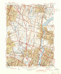
 1940 Weehawken1940 Print · USGSBergen and Hudson Counties are shown just before the wartime industrial boom, highlighting a landscape where massive rail yards met expansive tidal marshes. Researchers can trace ancestral roots through dozens of local landmarks like Flower Hill Cem, Bendix Airport, and the Hudson County Penitentiary.3 unique versions available
 - 1940 Map of Hackensack
 1940 Hackensack1940 Print · USGSBergen County suburban life comes into focus just before the mid-century boom, showing the transition from towns to dense residential grids. Genealogists can trace family plots at Riverside Cemetery or locate early schools like Steuben Sch and Willard Sch.3 unique versions available
 - 1942 Map of Passaic
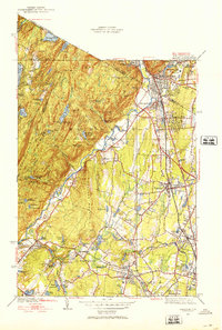
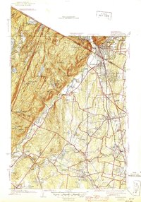
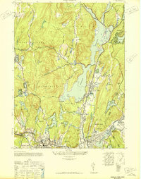
 1942 Passaic1942 Print · USGSNorthern New Jersey and New York harbor appear in detail at the start of the war, showing a landscape of burgeoning suburbs and vital industry. Trace family roots and local history across the Passaic River valley, from Paterson to the Watchung Mountains.
 - 1943 Map of Franklin Furnace
 1943 Franklin Furnace1943 Print · USGSMid-century Sussex County is defined here by its deep mining roots and mountain reservoirs. Trace the industrial landscape of Franklin and Ogdensburg through landmarks like the N J Zinc Co, the Stockholm School, and the Lehigh and Hudson River.
 - 1943 Map of Newfoundland
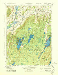
 1943 Newfoundland1943 Print · USGSThe Pequannock River valley and its surrounding ridges are captured here during the Second World War. Researchers can trace the New York Susquehanna and Western rail line through Newfoundland or locate landmarks like the Fire House and West Milford School.
 - 1943 Map of Weehawken
 1943 Weehawken1943 Print · USGSNorthern New Jersey during the Second World War was a vital industrial hub of rail yards and river commerce. Researchers can trace ancestral roots through urban street grids and find landmarks like the Monastery, Bendix Airport, and Secaucus Yards.
 - 1943 Map of Greenwood Lake
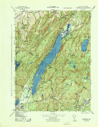 1943 Greenwood Lake1943 Print · USGSGreenwood Lake and the surrounding Highlands are captured during the early 1940s, revealing a landscape defined by iron industry and lakeside settlement. Genealogists and researchers can locate the Ringwood Iron Plant Mine, St Francis School, and the Erie Ringwood Branch railroad.
 - 1943 Map of Wawayanda
 1943 Wawayanda1943 Print · USGSThe New York and New Jersey borderlands appear here in the early 1940s as a landscape of highland lakes and valley rail stops. Genealogists and local historians can trace the transit corridor of the Lehigh and Hudson River railroad and locate old rural landmarks like the New Milford School and Maple Grange.2 unique versions available
 - 1943 Map of Ramsey
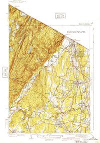
 1943 Ramsey1943 Print · USGSThe Ramapo Valley comes into sharp focus during the 1940s as rail-side communities like Ramsey and Allendale expand along the Erie RR. Researchers can locate specialized sites from the Don Bosco Institute to high-altitude landmarks like Hawk Rock and Houvenkopf Mtn Sch.2 unique versions available
 - 1943 Map of Pompton Plains, 1947 Print
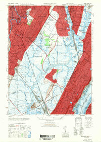
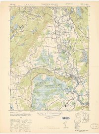 1943 Pompton Plains1947 Print · USGSIn the New Jersey valley of the Passaic, these mid-century Morris County communities are shown just before postwar suburbanization. Researchers can trace the junction of the Erie RR and Lackawanna RR or locate early airfields like North Jersey Airport and Murchia Airport.
 - 1944 Map of Paterson
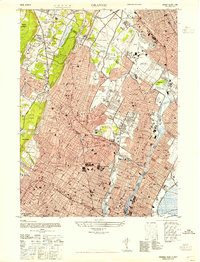
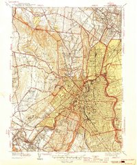 1944 Paterson1944 Print · USGSIn the mid-1940s, the industrial corridor of northern New Jersey centered on Paterson was a complex network of rail lines and early airports. Researchers can trace historic property boundaries and community institutions like St Michaels Orphanage, Murchio Airport, and the Laurel Grove Cem.2 unique versions available
 - 1944 Map of Newark, 1971 Print
 1944 Newark1971 Print · USGSThe industrial corridor from Philadelphia to New York was in a period of massive transition during the mid-forties. Genealogists and researchers can trace the rail lines of the Lehigh Valley RR, locate military installations like Picatinny Arsenal, and explore the early sprawl near Levittown.5 unique versions available
 - 1945 Map of Ramsey
 1945 Ramsey1945 Print · USGSThe New York and New Jersey borderlands come alive in the mid-1940s, showing a region defined by the Ramapo Mountains and the busy Erie railroad. Trace family roots and local history through the streets of Ramsey, Suffern, and the Don Bosco Institute.2 unique versions available
 - 1947 Map of Weehawken
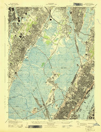
 1947 Weehawken1947 Print · USGSNorthwestern New Jersey’s industrial heartland is captured here at a post-war peak of rail and aviation development. Genealogists and historians can trace the intricate rail networks of the Secaucus Yards or locate local landmarks like Lodi Cem and Bendix Airport.
 - 1947 Map of Orange
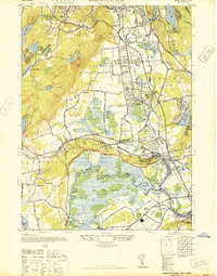
 1947 Orange1947 Print · USGSEssex County in the late 1940s reveals a bustling landscape of industrial rail lines and developing suburban neighborhoods. Trace family roots and local landmarks from Overbrook Hospital to the fairways of Montclair Golf Course and Nutley.
 - 1947 Map of Pompton Plains
 1947 Pompton Plains1947 Print · USGSNorth Jersey was a hub of early aviation and rail travel in the late 1940s, where small airfields and major rail lines intersected. You can trace historic routes through Pompton Plains, locate North Jersey Airport, and follow the Erie RR through the valley.2 unique versions available
 - 1948 Map of Wanaque
 1948 Wanaque1948 Print · USGSNorthern New Jersey's Highlands were entering a period of significant post-war growth when this survey recorded the communities around the Wanaque Reservoir. Genealogists and local historians can trace family roots in Haskell, Bloomingdale, and Midvale, or locate landmarks like the Aquehonga Sch.2 unique versions available
 - 1949 Map of Newark
 1949 Newark1949 Print · USGSThe industrial corridor between Philadelphia and New York comes alive in this post-war survey. Genealogists and historians can trace the massive rail networks of the Reading Railroad and locate major installations like Fort Dix or Picatinny Arsenal.2 unique versions available
End of results
Showing maps 1-19 of 19
Top cities of Passaic County
- Paterson historical maps
- Clifton historical maps
- Passaic historical maps
- Wayne historical maps
- West Milford historical maps
- Hawthorne historical maps
See more
Frequently asked questions
- What are the different types of historical maps available for Passaic County?
- What is the oldest map of Passaic County?
- Where can I purchase historical maps of Passaic County for my home or office?
- Where can I download high-res historical maps of Passaic County?
- Are there historical topographic maps available for Passaic County?
- Is there historical aerial imagery available for Passaic County?
- Where are historical maps of Passaic County sourced from?