1990s Maps of Fort Mott, Pennsville Township
Explore 2 historic maps of Fort Mott from the 1990s. These maps offer a rare glimpse into what life looked like during the 1990s — showing old roads, neighborhoods, homes, and landmarks that have changed or disappeared over time.
Whether you're researching your family's past, planning a metal detecting trip, or studying how Fort Mott's landscape evolved across the 1990s, these high-resolution maps are a powerful tool for exploring the history of this region.
- Focus on a specific era: All maps on this page are from the 1990s, giving you a focused view of this time period.
- See what’s changed: Compare century-old streets, trails, and buildings to today's modern landscape using overlays and satellite layers.
- Research with precision: Use these maps for genealogy, historical research, land use analysis, or educational projects.
- View, download, or print: Maps are fully viewable online in high resolution, and can be downloaded or printed for your own records.
Start exploring Fort Mott's history through authentic maps from the 1990s. This is your window into the past.
Fort Mott, Pennsville Township maps
(2)- 1993 Map of Delaware City
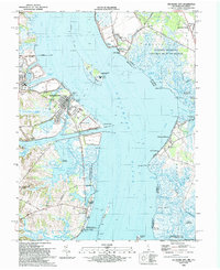 1993 Delaware City1993 Print · USGSThe Delaware riverfront and its coastal defenses appear in detail during the early nineties, showing the historic corridor between Delaware and New Jersey. Genealogists and historians can trace riverside settlements like Port Penn, the site of Fort Elfsborg, and the Finns Point National Cemetery.
 - 1999 Map of Delaware City, 2001 Print
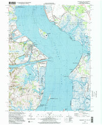 1999 Delaware City2001 Print · USGSThe Delaware River shoreline at the close of the twentieth century reveals a landscape defined by historic river forts and sprawling coastal wetlands. Researchers can trace the heritage of Delaware City and Port Penn or locate the Finns Point National Cemetery.
End of results
Showing maps 1-2 of 2
Top cities near Fort Mott
- Wilmington historical maps
- Chester historical maps
- Newark historical maps
- Hockessin historical maps
- Pennsville Township historical maps
- New Garden Township historical maps
See more
Frequently asked questions
- What are the different types of historical maps available for Fort Mott?
- What is the oldest map of Fort Mott?
- Where can I purchase historical maps of Fort Mott for my home or office?
- Where can I download high-res historical maps of Fort Mott?
- Are there historical topographic maps available for Fort Mott?
- Is there historical aerial imagery available for Fort Mott?
- Where are historical maps of Fort Mott sourced from?