Old Maps of Franklin Township, New Jersey
Explore 80 old maps of Franklin Township, spanning from 1888 to today. These high-resolution historic maps reveal how streets, neighborhoods, landmarks, and natural features evolved over time — perfect for genealogy, metal detecting, research, and local history exploration.
What you can do with these maps:
- See how Franklin Township changed over time: Compare historical maps to modern-day views to trace roads, homesites, rail lines & more.
- View detailed metadata: Each map includes creators, publishers, year, scale, and archive source.
- Overlay maps with satellite & LiDAR: Visualize the past alongside modern tools to explore terrain & human change.
- Trusted historical sources: Maps sourced from the USGS, Library of Congress, and other archives.
- Access maps your way: View online, download high-res files, or order prints for personal or research use.
Start exploring old maps of Franklin Township to uncover forgotten places, hidden landmarks, and the deep history beneath your feet.
Franklin Township, NJ maps
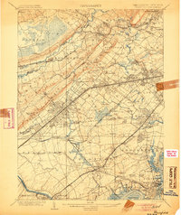
(80)- 1888 Map of Plainfield
 1888 Plainfield1888 Print · USGSNorth-central New Jersey is captured in the late nineteenth century as the rail network rapidly transformed small villages into vital industrial hubs. Genealogists and local researchers can trace the early footprints of Perth Amboy, Metuchen, and Dunellen alongside vanished local place names like Samptown.
 - 1888 Map of New Brunswick
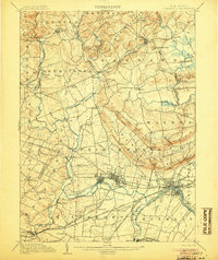
 1888 New Brunswick1888 Print · USGSMiddlesex County in the 1880s is shown here as a bustling hub of early rail and river industry. Genealogists and local historians can trace family roots through historic settlements like Old Bridge, Jamesburgh, and the preserved Monmouth Battle Ground.
 - 1888 Map of Princeton
 1888 Princeton1888 Print · USGSCentral New Jersey in the late nineteenth century is defined here by its critical canal and rail corridors connecting thriving agricultural villages. Genealogists and historians can trace family-named sites and early junctions like Grover's Mill, Griggstown, and the rail hub at Monmouth Junction.
 - 1891 Map of Somerville
 1891 Somerville1891 Print · USGSSomerset County was a bustling corridor of industry and rail commerce at the close of the nineteenth century. Genealogists and local historians can trace family roots through specific stops like North Branch Depot or explore the early infrastructure of Bound Brook and the Water Power Cos Raceway.2 unique versions available
 - 1893 Map of New Brunswick
 1893 New Brunswick1893 Print · USGSMiddlesex and Monmouth counties were thriving rail hubs in the 1890s, where heavy industry met Revolutionary history. Genealogists and collectors can trace family roots through small settlements like Texas and Spotswood or locate the State Reform School and Monmouth Battle Ground.2 unique versions available
 - 1893 Map of Plainfield
 1893 Plainfield1893 Print · USGSIn the late nineteenth century, the corridor between the Orange Mountains and the Raritan River was rapidly transforming into a dense rail-and-commuter network. Trace the early footprints of settlements like Feltville and Chatham, or locate vanished industries near Branch Mills and Ash Swamp.2 unique versions available
 - 1893 Map of Somerville
 1893 Somerville1893 Print · USGSSomerset County in the late nineteenth century is a hub of rail-driven commerce and riverfront industry. Local historians can trace the early footprints of Bernardsville and Basking Ridge or locate vanished landmarks like Burnt Mill and North Branch Depot.
 - 1894 Map of Princeton
 1894 Princeton1894 Print · USGSCentral New Jersey is captured here in the late nineteenth century as its river-and-canal economy transitioned to a powerhouse of rail travel. Genealogists and historians can trace the early footprints of Princeton, the industrial Delaware and Raritan Canal, and rural stops like Grover Mill.2 unique versions available
 - 1898 Map of Plainfield
 1898 Plainfield1898 Print · USGSNorth-central New Jersey at the close of the nineteenth century shows a landscape defined by the ridges of the Watchung Mountains and a rapidly expanding rail network. Genealogists and local historians can trace early property patterns and settlements like Feltville, Connecticut Farms, and the estates near Baltusrol.2 unique versions available
 - 1898 Map of Somerville
 1898 Somerville1898 Print · USGSSomerset County in the late nineteenth century is a landscape of established river towns and critical rail junctions. Genealogists and historians can trace the growth of Somerville, locate small communities like Pluckemin, or follow the Water Power Cos Raceway near Raritan.2 unique versions available
 - 1900 Map of Passaic
 1900 Passaic1900 Print · USGSNorthern New Jersey and the New York Harbor are captured here at the close of the nineteenth century, showing a landscape defined by rail, river, and coastal defense. Researchers can trace the original path of the Morris Canal, locate Seton Hall College, and explore the batteries at Fort Wadsworth.
 - 1900 Map of Raritan
 1900 Raritan1900 Print · USGSNorth Jersey in the late nineteenth century was a complex web of mountain ridges and vital rail corridors. Researchers can trace ancestral routes through old junctions like High Bridge, industrial sites at Mine Hill, and the shores of Lake Hopatcong.
 - 1901 Map of New Brunswick
 1901 New Brunswick1901 Print · USGSMiddlesex and Monmouth counties are depicted here at the height of the railroad era, as industrial centers like New Brunswick grew alongside rural farmlands. Genealogists and historians can trace family-named landmarks and old hamlets from Old Church and Matchaponix to the site of the Monmouth Battle Ground.5 unique versions available
 - 1902 Map of Navesink
 1902 Navesink1902 Print · USGSCoastal New Jersey and the Raritan valley are shown here at the turn of the century, when industrial hubs and maritime defenses defined the shoreline. Genealogists can trace family roots through settlements like Old Bridge and Milltown, or locate local landmarks like the State Reform School.3 unique versions available
 - 1905 Map of Plainfield
 1905 Plainfield1905 Print · USGSNorth-central New Jersey at the turn of the century shows a landscape transitioning from rural townships to a bustling suburban and industrial network. Researchers can trace early property patterns and rail expansion through Great Swamp, Washington Rock, and Baltusrol.6 unique versions available
 - 1905 Map of Raritan
 1905 Raritan1905 Print · USGSNorthern New Jersey's ridges and valleys are meticulously detailed here at the turn of the century. You can trace the complex rail networks of the Lehigh Valley R.R. and locate family landmarks from Swayze Mills to the Powder Depot near Picatinny Peak.2 unique versions available
 - 1905 Map of Somerville
 1905 Somerville1905 Print · USGSCentral New Jersey at the start of the twentieth century shows a landscape shaped by the Raritan River and early rail expansion. Researchers can trace the Delaware and Raritan Canal, locate landmarks like Chimney Rock, and find old centers like Pluckemin and Bernardsville.3 unique versions available
 - 1905 Map of Passaic
 1905 Passaic1905 Print · USGSNorthern New Jersey and Staten Island appear here at a pivotal moment of early 20th-century growth and industrialization. Researchers can trace the development of transit hubs like Convent Sta. or locate legacy landmarks including Hillside Cemetery and the Moravian Cemetery.4 unique versions available
 - 1906 Map of Princeton
 1906 Princeton1906 Print · USGSNew Jersey’s educational and transportation corridors are captured here in the early twentieth century, showing a landscape defined by canals and competing rail lines. Genealogists can trace family roots through settlements like Princeton, Rocky Hill, and Plainsboro.4 unique versions available
 - 1907 Map of Trenton
 1907 Trenton1907 Print · USGSThe Delaware River valley hums with turn-of-the-century industry and transport as river canals and railroads converge between New Jersey and Pennsylvania. Genealogists and local historians can trace the footprint of the George School, find early post offices like Holland PO, or locate old mill sites such as Blackwells Mills.4 unique versions available
 - 1919 Map of New Brunswick, 1921 Print
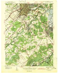
 1919 New Brunswick1921 Print · USGSMiddlesex and Monmouth counties are depicted here in the years following the Great War, when rail lines and river commerce still drove the region’s growth. Researchers can trace the sprawling Pennsylvania Railroad network through industrial hubs like Jamesburg or visit the hallowed Monmouth Battle Ground.
 - 1921 Map of Plainfield
 1921 Plainfield1921 Print · USGSNew Jersey's industrial corridor meets the ridges of the First and Second Mountains in the early twenties. Genealogists can trace family names and small settlements like Raritan Landing, Smalleytown, and the grounds of the New Jersey Reformatory.
 - 1942 Map of Hightstown
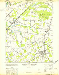 1942 Hightstown1942 Print · USGSCentral New Jersey during the early years of the war displays a unique blend of scholarly institutions and agricultural hamlets. Researchers can trace the development of Hightstown and Plainsboro, or locate sites like Grovers Mills and the Peddie Prep Sch.
 - 1942 Map of New Brunswick
 1942 New Brunswick1942 Print · USGSNew Brunswick and its surrounding Middlesex County townships are shown just before the war, when rail lines and early highways defined the region. Genealogists can trace family names at local crossroads like Berdines Cor or locate the McGinnis Sch and Sejeh Yehudo Cemetery.2 unique versions available
 - 1942 Map of Passaic
 1942 Passaic1942 Print · USGSNorthern New Jersey and New York harbor appear in detail at the start of the war, showing a landscape of burgeoning suburbs and vital industry. Trace family roots and local history across the Passaic River valley, from Paterson to the Watchung Mountains.
Showing maps 1-25 of 80
Top cities near Franklin Township
- Edison historical maps
- Woodbridge Township historical maps
- Hamilton Township historical maps
- Trenton historical maps
- Old Bridge Township historical maps
- Piscataway Township historical maps
See more
Top neighborhoods of Franklin Township
- Blackwells Mills historical maps
- Clyde historical maps
- Griggstown historical maps
- Middlebush historical maps
- Rockingham historical maps
- Sunset Hill Garden historical maps
See more
Frequently asked questions
- What are the different types of historical maps available for Franklin Township?
- What is the oldest map of Franklin Township?
- Where can I purchase historical maps of Franklin Township for my home or office?
- Where can I download high-res historical maps of Franklin Township?
- Are there historical topographic maps available for Franklin Township?
- Is there historical aerial imagery available for Franklin Township?
- Where are historical maps of Franklin Township sourced from?