1940s Maps of Stillwater Township, New Jersey
Explore 3 historic maps of Stillwater Township from the 1940s. These maps offer a rare glimpse into what life looked like during the 1940s — showing old roads, neighborhoods, homes, and landmarks that have changed or disappeared over time.
Whether you're researching your family's past, planning a metal detecting trip, or studying how Stillwater Township's landscape evolved across the 1940s, these high-resolution maps are a powerful tool for exploring the history of this region.
- Focus on a specific era: All maps on this page are from the 1940s, giving you a focused view of this time period.
- See what’s changed: Compare century-old streets, trails, and buildings to today's modern landscape using overlays and satellite layers.
- Research with precision: Use these maps for genealogy, historical research, land use analysis, or educational projects.
- View, download, or print: Maps are fully viewable online in high resolution, and can be downloaded or printed for your own records.
Start exploring Stillwater Township's history through authentic maps from the 1940s. This is your window into the past.
Stillwater Township, NJ maps
(3)- 1943 Map of Lake Maskenozha
 1943 Lake Maskenozha1943 Print · USGSThe Delaware River valley at the height of the war years is documented here in detail, showing the borderlands of Pike County and Sussex County. Genealogists and local historians can trace old homesteads and landmarks like Wallpack Center, Egypt Mills, and the Wallpack Center School.3 unique versions available
 - 1943 Map of Culvers Gap
 1943 Culvers Gap1943 Print · USGSThe Delaware River valley and Kittatinny Mountains meet in this early 1940s survey of the New Jersey and Pennsylvania border. Researchers can trace rural life through landmarks like Dingmans Ferry, Snooks Lumber Mill, and the Sandyston School before the landscape was modernly altered.2 unique versions available
 - 1943 Map of Flatbrookville
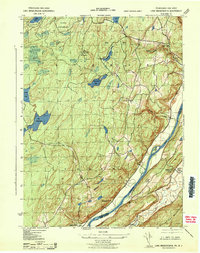
 1943 Flatbrookville1943 Print · USGSThe Delaware River borderlands are captured here during the 1940s, showing a landscape of mountain ridges and riverside ferry crossings. Genealogists can locate old homesteads and landmarks like Wintermutes Foundry, Newbakers Corners, and Stillwater TWS School.
End of results
Showing maps 1-3 of 3
Top cities near Stillwater Township
- Mount Olive historical maps
- Roxbury Township historical maps
- Sparta Township historical maps
- Hopatcong historical maps
- Wantage historical maps
- Hackettstown historical maps
See more
Top neighborhoods of Stillwater Township
- Middleville historical maps
- Five Points historical maps
- Swartswood historical maps
- Paulins Kill historical maps
Frequently asked questions
- What are the different types of historical maps available for Stillwater Township?
- What is the oldest map of Stillwater Township?
- Where can I purchase historical maps of Stillwater Township for my home or office?
- Where can I download high-res historical maps of Stillwater Township?
- Are there historical topographic maps available for Stillwater Township?
- Is there historical aerial imagery available for Stillwater Township?
- Where are historical maps of Stillwater Township sourced from?