1900s (20th Century) Maps of Pueblo Alto, Albuquerque
Explore 10 historic maps of Pueblo Alto from the 1900s (20th Century). These maps offer a rare glimpse into what life looked like during the 1900s — showing old roads, neighborhoods, homes, and landmarks that have changed or disappeared over time.
Whether you're researching your family's past, planning a metal detecting trip, or studying how Pueblo Alto's landscape evolved across the 1900s, these high-resolution maps are a powerful tool for exploring the history of this region.
- Focus on a specific era: All maps on this page are from the 1900s, giving you a focused view of this time period.
- See what’s changed: Compare century-old streets, trails, and buildings to today's modern landscape using overlays and satellite layers.
- Research with precision: Use these maps for genealogy, historical research, land use analysis, or educational projects.
- View, download, or print: Maps are fully viewable online in high resolution, and can be downloaded or printed for your own records.
Start exploring Pueblo Alto's history through authentic maps from the 1900s. This is your window into the past.
Pueblo Alto, Albuquerque maps
(10)- 1934 Map of East Albuquerque
 1934 East Albuquerque1934 Print · USGSAlbuquerque's eastern reaches are captured in the mid-1930s just as federal and institutional growth began defining the city. Local historians can trace the early University of New Mexico campus and the original Albuquerque Landing Field.
 - 1938 Map of Albuquerque
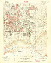
 1938 Albuquerque1938 Print · USGSAlbuquerque and the Rio Grande Valley are shown in the late 1930s, when irrigation ditches still defined the rural landscape between the river and the mountains. Researchers can trace ancestral lands through the Town of Atrisco Grant or locate landmarks like the U S Indian School and Old Albuquerque.
 - 1954 Map of Albuquerque East, 1955 Print
 1954 Albuquerque East1955 Print · USGSAlbuquerque’s post-war eastern expansion is documented here as neighborhoods rise toward the foothills and military installations. Trace mid-century landmarks like the Del Norte Airport, the University of New Mexico, and the Cactus Drive-in Theater.
 - 1958 Map of Albuquerque
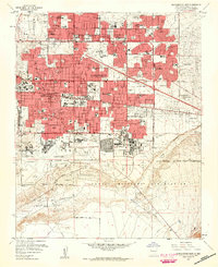
 1958 Albuquerque1958 Print · USGSAlbuquerque and the surrounding high desert are captured here during a period of massive federal expansion and postwar growth. Researchers can trace the development of Kirtland Air Force Base, find ancestral homes in Pueblo de Santa Ana, or locate industrial sites like the Jackpile Mine.
 - 1960 Map of Albuquerque East
 1960 Albuquerque East1960 Print · USGSAlbuquerque's eastern neighborhoods and the foothills of the Sandia Mountains are captured here during a decade of rapid growth. Researchers can locate mid-century schools and churches like Pius X High Sch and Queen of Heaven Ch, or trace the boundaries of the Sandia Military Reservation.3 unique versions available
 - 1962 Map of Albuquerque
 1962 Albuquerque1962 Print · USGSAlbuquerque and the surrounding high desert are captured here in the early 1960s during a period of intense mineral and military growth. Genealogists and historians can locate early schools like the Pueblo Pintado School, major industrial sites like the Jackpile Mine, and the sprawling Kirtland Air Force Base.
 - 1963 Map of Albuquerque, 1965 Print
 1963 Albuquerque1965 Print · USGSMid-century New Mexico unfolds across this map, showcasing the intersection of ancient pueblos, modern military bases, and historic mining districts. Trace family roots and local history through the Ortiz Mine, Seven Lakes Trading Post, and Alameda.3 unique versions available
 - 1978 Map of Albuquerque, 1986 Print
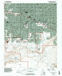
 1978 Albuquerque1986 Print · USGSGreater Albuquerque and the Rio Grande valley are captured here during a period of significant suburban expansion in the late seventies. Researchers can trace the early Subdivision Road Pattern near Rio Rancho and the historic footprints of Santa Ana Pueblo and Bernalillo.
 - 1983 Map of Albuquerque, 1984 Print
 1983 Albuquerque1984 Print · USGSCentral New Mexico in the early eighties shows a landscape where ancient pueblos and modern aerospace hubs meet. Trace the routes of the Atchison Topeka and Santa Fe RR or locate landmarks like Kirtland Air Force Base, Madrid, and the Sandia Mountains.
 - 1990 Map of Albuquerque East, 1996 Print
 1990 Albuquerque East1996 Print · USGSAlbuquerque and its eastern suburbs are captured here during a period of rapid 1990s growth. Researchers can trace the massive footprints of Kirtland Air Force Base, the University of New Mexico, and the State Fairground.
End of results
Showing maps 1-10 of 10
Frequently asked questions
- What are the different types of historical maps available for Pueblo Alto?
- What is the oldest map of Pueblo Alto?
- Where can I purchase historical maps of Pueblo Alto for my home or office?
- Where can I download high-res historical maps of Pueblo Alto?
- Are there historical topographic maps available for Pueblo Alto?
- Is there historical aerial imagery available for Pueblo Alto?
- Where are historical maps of Pueblo Alto sourced from?