1940s Maps of Hurley, New Mexico
Explore 3 historic maps of Hurley from the 1940s. These maps offer a rare glimpse into what life looked like during the 1940s — showing old roads, neighborhoods, homes, and landmarks that have changed or disappeared over time.
Whether you're researching your family's past, planning a metal detecting trip, or studying how Hurley's landscape evolved across the 1940s, these high-resolution maps are a powerful tool for exploring the history of this region.
- Focus on a specific era: All maps on this page are from the 1940s, giving you a focused view of this time period.
- See what’s changed: Compare century-old streets, trails, and buildings to today's modern landscape using overlays and satellite layers.
- Research with precision: Use these maps for genealogy, historical research, land use analysis, or educational projects.
- View, download, or print: Maps are fully viewable online in high resolution, and can be downloaded or printed for your own records.
Start exploring Hurley's history through authentic maps from the 1940s. This is your window into the past.
Hurley, NM maps
(3)- 1948 Map of Hurley East, 1976 Print
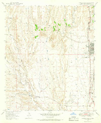
 1948 Hurley East1976 Print · USGSGrant County is captured in the late 1940s, showing the intersection of industrial processing and the high desert. Researchers can trace early infrastructure around Hurley and follow the paths of Whitewater Creek and Lambright Draw through the hills.
 - 1949 Map of Hurley East
 1949 Hurley East1949 Print · USGSThe mining town of Hurley and its surrounding desert canyons are captured here in the late 1940s. Genealogists and historians can trace local water and mineral sites such as Whitewater Creek, a remote Prospect, and the winding Lampright Draw.
 - 1949 Map of Hurley West, 1966 Print
 1949 Hurley West1966 Print · USGSThe mining and rail landscape of Grant County comes to life in this mid-century survey. Genealogists and historians can trace the foundations of Hurley, locate the Hurley Cem, and follow the Atchison Topeka and Santa Fe railroad through San Vincente.2 unique versions available
End of results
Showing maps 1-3 of 3
Top cities near Hurley
Frequently asked questions
- What are the different types of historical maps available for Hurley?
- What is the oldest map of Hurley?
- Where can I purchase historical maps of Hurley for my home or office?
- Where can I download high-res historical maps of Hurley?
- Are there historical topographic maps available for Hurley?
- Is there historical aerial imagery available for Hurley?
- Where are historical maps of Hurley sourced from?