Old Maps of Dehaven, New Mexico for Hiking & Exploration
Hike through history with 10 historic maps of Dehaven. Explore old trails, ghost towns, and forgotten backroads — perfect for outdoor adventurers and local explorers.
- Rediscover forgotten places: Map out old mining camps, roads, and footpaths that no longer exist on modern maps.
- Layer with modern tools: Combine with LiDAR or satellite views to plan hikes through historical terrain.
- Made for exploration: Popular among hikers, overlanders, and local history lovers.
Use these maps to find adventure and explore the hidden past of Dehaven.
Dehaven, NM maps
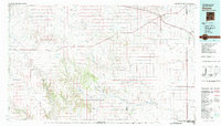
(10)- 1954 Map of Dalhart, 1967 Print
 1954 Dalhart1967 Print · USGSThe High Plains at the junction of four states come alive in the mid-fifties, showing a landscape of rail-hub towns and cattle country. Trace the Old Santa Fe Trail or locate mid-century industrial sites like the Dry ice plant and Carbon Dioxide Works.2 unique versions available
 - 1958 Map of Dalhart
 1958 Dalhart1958 Print · USGSThe High Plains of the tri-state border region come alive in this mid-century survey of the ranching and rail territory around the Texas Panhandle. Genealogists and historians can trace the paths of the Atchison Topeka & Santa Fe Ry, military outposts like Dalhart Air Force No 1, and early settlements such as Pasamonte and Texline.2 unique versions available
 - 1962 Map of Dalhart
 1962 Dalhart1962 Print · USGSThe High Plains and volcanic peaks of the tri-state area are shown in detail during the early sixties. Genealogists and historians can trace the rail corridors of the Fort Worth and Denver and find industrial sites like the Cactus Ordnance Works or the Beaver Meade & Englewood Grain Elevator.
 - 1973 Map of Yates SE, 1977 Print
 1973 Yates SE1977 Print · USGSThe high plains of Harding and Union counties are shown in the early seventies, a landscape of ranching and energy. Researchers can locate the small settlement of Clavels, several Falls along Alamocita Creek, and an isolated rural Cem.
 - 1982 Map of Clayton, 1983 Print
 1982 Clayton1983 Print · USGSThe high plains of northeast New Mexico and the Texas panhandle appear here in the early eighties, centered on the ranching hub of Clayton. Genealogists and historians can trace the paths of the Colorado and Southern railroad or locate remote settlements like Miera, Beenham, and Sofia.
 - 2010 Map of Yates SE, 2010 Print
 2010 Yates SE2010 Print · USGSCovers Dehaven, including Union County, Harding County, and other nearby areas
 - 2013 Map of Yates SE, 2013 Print
 2013 Yates SE2013 Print · USGSCovers Dehaven, including Union County, Harding County, and other nearby areas
 - 2017 Map of Yates SE, 2017 Print
 2017 Yates SE2017 Print · USGSCovers Dehaven, including Union County, Harding County, and other nearby areas
 - 2020 Map of Yates SE, 2020 Print
 2020 Yates SE2020 Print · USGSCovers Dehaven, including Union County, Harding County, and other nearby areas
 - 2023 Map of Yates SE, 2023 Print
 2023 Yates SE2023 Print · USGSNortheastern New Mexico ranching country is documented here in the early twenty-first century, showing the remote high plains along the Union and Harding County line. Researchers can trace land holdings and access routes like Romero Bros Rd and Lovato Rd near the prominent Ute Creek Mesa.
End of results
Showing maps 1-10 of 10
Frequently asked questions
- What are the different types of historical maps available for Dehaven?
- What is the oldest map of Dehaven?
- Where can I purchase historical maps of Dehaven for my home or office?
- Where can I download high-res historical maps of Dehaven?
- Are there historical topographic maps available for Dehaven?
- Is there historical aerial imagery available for Dehaven?
- Where are historical maps of Dehaven sourced from?