1980s Maps of Eaton Place, New Mexico
Explore 2 historic maps of Eaton Place from the 1980s. These maps offer a rare glimpse into what life looked like during the 1980s — showing old roads, neighborhoods, homes, and landmarks that have changed or disappeared over time.
Whether you're researching your family's past, planning a metal detecting trip, or studying how Eaton Place's landscape evolved across the 1980s, these high-resolution maps are a powerful tool for exploring the history of this region.
- Focus on a specific era: All maps on this page are from the 1980s, giving you a focused view of this time period.
- See what’s changed: Compare century-old streets, trails, and buildings to today's modern landscape using overlays and satellite layers.
- Research with precision: Use these maps for genealogy, historical research, land use analysis, or educational projects.
- View, download, or print: Maps are fully viewable online in high resolution, and can be downloaded or printed for your own records.
Start exploring Eaton Place's history through authentic maps from the 1980s. This is your window into the past.
Eaton Place, NM maps
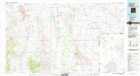
(2)- 1982 Map of Mount Baldy
 1982 Mount Baldy1982 Print · USGSHidalgo County's high desert peaks and canyons are captured in detail here during the early eighties. Researchers and hikers can locate specific water sources like Maverick Spring and Slover Tank, or trace the rugged geography of Post Office Canyon and Mount Baldy.
 - 1983 Map of Animas
 1983 Animas1983 Print · USGSSouthern New Mexico’s Bootheel remains a landscape of high-desert ranching and remote mining districts during the early eighties. Researchers can trace the Southern Pacific Railroad past historic hubs like Animas and Hachita or locate mining sites such as the Gillespie Mine.
End of results
Showing maps 1-2 of 2
Top cities near Eaton Place
Frequently asked questions
- What are the different types of historical maps available for Eaton Place?
- What is the oldest map of Eaton Place?
- Where can I purchase historical maps of Eaton Place for my home or office?
- Where can I download high-res historical maps of Eaton Place?
- Are there historical topographic maps available for Eaton Place?
- Is there historical aerial imagery available for Eaton Place?
- Where are historical maps of Eaton Place sourced from?