1940s Maps of Elwood, New Mexico
Explore 3 historic maps of Elwood from the 1940s. These maps offer a rare glimpse into what life looked like during the 1940s — showing old roads, neighborhoods, homes, and landmarks that have changed or disappeared over time.
Whether you're researching your family's past, planning a metal detecting trip, or studying how Elwood's landscape evolved across the 1940s, these high-resolution maps are a powerful tool for exploring the history of this region.
- Focus on a specific era: All maps on this page are from the 1940s, giving you a focused view of this time period.
- See what’s changed: Compare century-old streets, trails, and buildings to today's modern landscape using overlays and satellite layers.
- Research with precision: Use these maps for genealogy, historical research, land use analysis, or educational projects.
- View, download, or print: Maps are fully viewable online in high resolution, and can be downloaded or printed for your own records.
Start exploring Elwood's history through authentic maps from the 1940s. This is your window into the past.
Elwood, NM maps
(3)- 1940 Map of Orogrande, 1962 Print
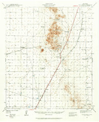 1940 Orogrande1962 Print · USGSThe Tularosa Valley and Jarilla Mountains are seen here as they appeared in 1940, during a period of active desert mining and ranching. Genealogists and historians can trace family operations at McNew Ranch and McGregor Ranch or locate old workings at the Iron Queen Mine and Nannie Beard Mine.
 - 1943 Map of Orogrande
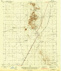 1943 Orogrande1943 Print · USGSOrogrande and the surrounding Tularosa Valley are shown at the height of the early 1940s mining and ranching era. Researchers can trace family-named sites like McNew Ranch or locate historical workings such as the Iron Queen Mine and Alice Mine.
 - 1948 Map of El Wood
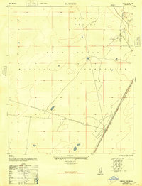 1948 El Wood1948 Print · USGSThe Tularosa Valley was undergoing a major transition in the late 1940s as ranchlands were absorbed into defense zones. Researchers can trace the Southern Pacific tracks past Elwood and locate local landmarks like McNew South Tank.
End of results
Showing maps 1-3 of 3
Top cities near Elwood
Frequently asked questions
- What are the different types of historical maps available for Elwood?
- What is the oldest map of Elwood?
- Where can I purchase historical maps of Elwood for my home or office?
- Where can I download high-res historical maps of Elwood?
- Are there historical topographic maps available for Elwood?
- Is there historical aerial imagery available for Elwood?
- Where are historical maps of Elwood sourced from?