1980s Maps of Villanueva, New Mexico
Explore 2 historic maps of Villanueva from the 1980s. These maps offer a rare glimpse into what life looked like during the 1980s — showing old roads, neighborhoods, homes, and landmarks that have changed or disappeared over time.
Whether you're researching your family's past, planning a metal detecting trip, or studying how Villanueva's landscape evolved across the 1980s, these high-resolution maps are a powerful tool for exploring the history of this region.
- Focus on a specific era: All maps on this page are from the 1980s, giving you a focused view of this time period.
- See what’s changed: Compare century-old streets, trails, and buildings to today's modern landscape using overlays and satellite layers.
- Research with precision: Use these maps for genealogy, historical research, land use analysis, or educational projects.
- View, download, or print: Maps are fully viewable online in high resolution, and can be downloaded or printed for your own records.
Start exploring Villanueva's history through authentic maps from the 1980s. This is your window into the past.
Villanueva, NM maps
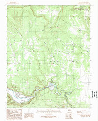
(2)- 1983 Map of Villanueva, 1984 Print
 1983 Villanueva1984 Print · USGSThe Pecos River valley and its high mesa surroundings are captured here in the early eighties. Researchers can trace historic river settlements like Villanueva and Sena, the route of the Atchison Topeka and Santa Fe railroad, and the high-desert terrain of Glorieta Mesa.
 - 1989 Map of Villanueva
 1989 Villanueva1989 Print · USGSUpper Pecos River valley life is preserved here in the late eighties, documenting the ancient settlements of Villanueva and El Cerrito. Genealogists and local historians can trace legacy land grants like San Miguel del Bado Tract No 1 and geographic markers such as Mesa Sombodoro.
End of results
Showing maps 1-2 of 2
Frequently asked questions
- What are the different types of historical maps available for Villanueva?
- What is the oldest map of Villanueva?
- Where can I purchase historical maps of Villanueva for my home or office?
- Where can I download high-res historical maps of Villanueva?
- Are there historical topographic maps available for Villanueva?
- Is there historical aerial imagery available for Villanueva?
- Where are historical maps of Villanueva sourced from?