1900s (20th Century) Maps of Escondida, New Mexico
Explore 9 historic maps of Escondida from the 1900s (20th Century). These maps offer a rare glimpse into what life looked like during the 1900s — showing old roads, neighborhoods, homes, and landmarks that have changed or disappeared over time.
Whether you're researching your family's past, planning a metal detecting trip, or studying how Escondida's landscape evolved across the 1900s, these high-resolution maps are a powerful tool for exploring the history of this region.
- Focus on a specific era: All maps on this page are from the 1900s, giving you a focused view of this time period.
- See what’s changed: Compare century-old streets, trails, and buildings to today's modern landscape using overlays and satellite layers.
- Research with precision: Use these maps for genealogy, historical research, land use analysis, or educational projects.
- View, download, or print: Maps are fully viewable online in high resolution, and can be downloaded or printed for your own records.
Start exploring Escondida's history through authentic maps from the 1900s. This is your window into the past.
Escondida, NM maps
(9)- 1906 Map of Socorro
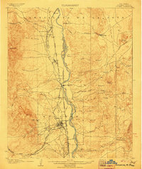 1906 Socorro1906 Print · USGSSocorro and the Rio Grande valley are captured here at the dawn of the twentieth century, as the railroad and mining industries reshaped the region. Genealogists and researchers can locate old sites like the School of Mines, the Dewey Mine, and the river crossing at Ford and Ferry.3 unique versions available
 - 1916 Map of La Joya
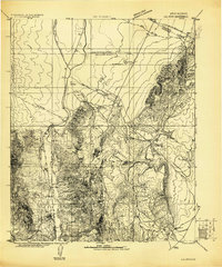 1916 La Joya1916 Print · USGSThe Rio Grande valley at the time of the Belen Cut Off's construction reveals a landscape of massive Spanish land grants and new rail towns. Trace early settlements like La Joya and Becker or geological landmarks like Pyramid Crater.
 - 1954 Map of Socorro, 1972 Print
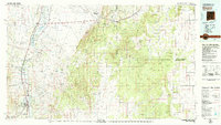
 1954 Socorro1972 Print · USGSMid-century New Mexico comes into focus as the Rio Grande valley and the surrounding high desert undergo post-war growth. Genealogists and historians can trace old mountain settlements like Tajique and Punta de Agua or locate remote sites like the Torrance Mine.2 unique versions available
 - 1958 Map of Socorro
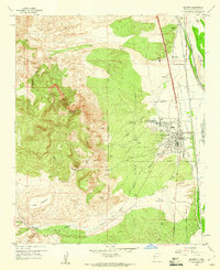
 1958 Socorro1958 Print · USGSNew Mexico's high desert during the late fifties reveals a landscape of massive land grants and remote mining outposts. Researchers can trace the path of the Atchison Topeka and Santa Fe railroad as it connects Socorro and Belen to industrial sites like the Manganese Mill.
 - 1959 Map of Socorro, 1960 Print
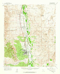
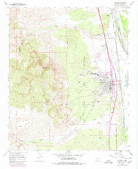
 1959 Socorro1960 Print · USGSSocorro and the Rio Grande valley are shown in detail during the late fifties as the town grew around the mining institute. Researchers can locate the San Miguel Ch, trace the Atchison Topeka and Santa Fe Railway, and find the Zimmerly Sch.2 unique versions available
 - 1959 Map of Socorro, 1962 Print
 1959 Socorro1962 Print · USGSSocorro and the Rio Grande valley are seen here in the late fifties, showcasing a high-desert landscape of irrigation ditches and rail-side villages. Researchers can trace the layout of the New Mexico Institute of Mining and Technology or locate the Dewey Lode Mine and Polvadera.
 - 1962 Map of Socorro
 1962 Socorro1962 Print · USGSCentral New Mexico comes alive in the early sixties as the rail-and-river corridor of the Rio Grande connects historic pueblos and ranching towns. Local historians can trace the route of the Atchison Topeka and Santa Fe through Belen or locate the Torrance Mine near Mountainair.
 - 1979 Map of Socorro
 1979 Socorro1979 Print · USGSThe Rio Grande corridor south of Belen comes into focus during the late seventies, showing the vital link between river-valley agriculture and high-desert ranching. Genealogists and historians can trace riverside settlements like Polvadera and La Joya or locate the Abo Mine and Dewey Lode Mine.2 unique versions available
 - 1979 Map of Socorro
 1979 Socorro1979 Print · USGSSocorro and the Rio Grande valley are seen here in the late seventies, revealing a landscape shaped by mountain peaks and complex river irrigation. Trace local history through the New Mexico Tech campus, San Miguel Cem, and the Dewey Lode Mine.
End of results
Showing maps 1-9 of 9
Top cities near Escondida
Frequently asked questions
- What are the different types of historical maps available for Escondida?
- What is the oldest map of Escondida?
- Where can I purchase historical maps of Escondida for my home or office?
- Where can I download high-res historical maps of Escondida?
- Are there historical topographic maps available for Escondida?
- Is there historical aerial imagery available for Escondida?
- Where are historical maps of Escondida sourced from?